Calvià geodata
Calvià (Balearic Islands) is a seat of a third-order administrative division; located in Spain in Europe/Madrid (GMT+2) time zone. With population of 51,774 people, there are 178 cities with bigger population in this country. Compared to other cities in Spain, 76.2% of cities are located further ↑North; 96.5% of cities are located further ←West and 85.9% of cities have higher elevation than Calvià. Note1


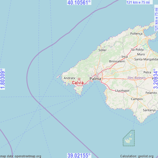
Calvià GPS coordinates[2]
39° 33' 56.52" North, 2° 30' 22.356" East
| Map corner | latitude | longitude |
|---|---|---|
| Upper-left | 40.10561°, | 1.80309° |
| Center: | 39.5657°, | 2.50621° |
| Lower-right: | 39.02155°, | 3.20934° |
| Map W x H: | 120.5×120.5 km | = 74.9×74.9mi |
| max Lat: | 43.74134° ⇑76.2% North |
| Calvià: | 39.5657° |
| min Lat: | ⇓23.8% South 27.64134° |
| min Long | Calvià | max Long |
| -18.00367° | 2.50621° | 4.2899° |
| W 96.5%⇐ | ⇒3.5% E |
Elevation
Elevation of Calvià is 125 m = 410 ft, and this is 473 m = 1552 ft below average elevation for this country.
| Max E: |
1682 m = 5518 ft | 85.9% |
| Avg. | 598 m = 1962 ft | |
| Calvià | 125 m = 410 ft | |
Min E: |
0 m = 0 ft | 14.1% |
See also: Calvià elevation on elevation.city.
Geographical zone
Calvià is located in North temperate zone (between Tropic of Cancer and the Arctic Circle). Distance of this Northern Tropic circle is 1793.4 km =1114.4 mi to South.| Distance of | km | miles | from Calvià |
|---|---|---|---|
| North Pole | 5607.8 | 3484.5 | to North |
| Arctic Circle | 3001.9 | 1865.3 | to North |
| Tropic Cancer | 1793.4 | 1114.4 | to South |
| Equator | 4399.3 | 2733.6 | to South |


Nearby cities:
15 places around Calvià: (largest is in red/bold)
• Andratx
7.5 km =4.7 mi,  278°
278°
• Banyalbufar
13.5 km =8.4 mi,  2°
2°
• Camp de Mar
7.7 km =4.8 mi,  246°
246°
• Coll d'en Rabassa
16.2 km =10.1 mi,  95°
95°
• El Toro
9.2 km =5.7 mi,  192°
192°
• Es Molinar
14.5 km =9 mi,  91°
91°
• Esporles
13 km =8.1 mi,  28°
28°
• Estellencs
10 km =6.2 mi,  347°
347°
• Magaluf
6.6 km =4.1 mi,  157°
157°
• Palma
12.4 km =7.7 mi, 88°
• Palmanova
5.4 km =3.4 mi,  148°
148°
• Peguera
5.9 km =3.7 mi,  237°
237°
• Puigpunyent
6.9 km =4.3 mi,  15°
15°
• Santa Ponsa
6.8 km =4.2 mi,  201°
201°
• Son Ferrer
7.7 km =4.8 mi,  183°
183°
In other languages:
- In Spanish: Calvià, Calviá
- In France: Calviá
- In Russian: Кальвия
- In Chinese: 卡尔维亚
Sources, notices
• [Note1] Compared only with cities in Spain existing in our database
• [Src1] Map data: © OpenStreetMap contributors (CC-BY-SA)
• [Src2] Other city data from geonames.org with taken over terms of usage.
• [Src3] Geographical zone / Annual Mean Temperature by Robert A. Rohde @ Wikipedia
