Castalla geodata
Castalla (Valencia) is a seat of a third-order administrative division; located in Spain in Europe/Madrid (GMT+2) time zone. With population of 10,327 people, there are 841 cities with bigger population in this country. Compared to other cities in Spain, 85% of cities are located further ↑North; 80.1% of cities are located further ←West and 53.9% of cities have lower elevation than Castalla. Note1


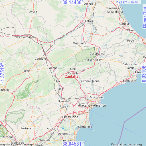
Castalla GPS coordinates[2]
38° 35' 48.984" North, 0° 40' 19.452" West
| Map corner | latitude | longitude |
|---|---|---|
| Upper-left | 39.14436°, | -1.37519° |
| Center: | 38.59694°, | -0.67207° |
| Lower-right: | 38.04531°, | 0.03106° |
| Map W x H: | 122.2×122.2 km | = 75.9×75.9mi |
| max Lat: | 43.74134° ⇑85% North |
| Castalla: | 38.59694° |
| min Lat: | ⇓15% South 27.64134° |
| min Long | Castalla | max Long |
| -18.00367° | -0.67207° | 4.2899° |
| W 80.1%⇐ | ⇒19.9% E |
Elevation
Elevation of Castalla is 700 m = 2297 ft, and this is 102 m = 335 ft above average elevation for this country.
| Max E: |
1682 m = 5518 ft | 46.1% |
| Castalla | 700 m 2297 ft | |
| Avg. | 598 m = 1962 ft | |
Min E: |
0 m = 0 ft | 53.9% |
See also: Spain elevation on elevation.city.
Geographical zone
Castalla is located in North temperate zone (between Tropic of Cancer and the Arctic Circle). Distance of this Northern Tropic circle is 1685.7 km =1047.4 mi to South.| Distance of | km | miles | from Castalla |
|---|---|---|---|
| North Pole | 5715.5 | 3551.4 | to North |
| Arctic Circle | 3109.6 | 1932.2 | to North |
| Tropic Cancer | 1685.7 | 1047.4 | to South |
| Equator | 4291.6 | 2666.7 | to South |


Nearby cities:
15 places around Castalla: (largest is in red/bold)
• Agost
17.7 km =11 mi,  170°
170°
• Alcoy
21 km =13 mi,  54°
54°
• Alfafara
22.1 km =13.7 mi,  27°
27°
• Beneixama
14.1 km =8.8 mi,  324°
324°
• Biar
8.9 km =5.5 mi,  295°
295°
• Bocairent
19.5 km =12.1 mi,  14°
14°
• Cañada
15 km =9.3 mi, 304°
• Elda
16.8 km =10.4 mi,  218°
218°
• Ibi
9.2 km =5.7 mi,  69°
69°
• Jijona
16 km =9.9 mi,  112°
112°
• Onil
3.2 km =2 mi,  358°
358°
• Sax
14.3 km =8.9 mi,  242°
242°
• Tibi
11 km =6.8 mi,  131°
131°
• Torremanzanas
22 km =13.7 mi,  87°
87°
• Villena
17.4 km =10.8 mi,  284°
284°
Sources, notices
• [Note1] Compared only with cities in Spain existing in our database
• [Src1] Map data: © OpenStreetMap contributors (CC-BY-SA)
• [Src2] Other city data from geonames.org with taken over terms of usage.
• [Src3] Geographical zone / Annual Mean Temperature by Robert A. Rohde @ Wikipedia
