Cañada geodata
Cañada (Valencia) is a seat of a third-order administrative division; located in Spain in Europe/Madrid (GMT+2) time zone. In our database, there are 6762 cities with bigger population. Compared to other cities in Spain, 84.5% of cities are located further ↑North; 78.6% of cities are located further ←West and 57.2% of cities have higher elevation than Cañada. Note1


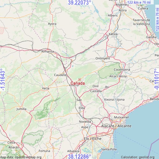
Cañada GPS coordinates[2]
38° 40' 26.04" North, 0° 48' 47.88" West
| Map corner | latitude | longitude |
|---|---|---|
| Upper-left | 39.22073°, | -1.51643° |
| Center: | 38.6739°, | -0.8133° |
| Lower-right: | 38.12286°, | -0.11017° |
| Map W x H: | 122.1×122.1 km | = 75.9×75.9mi |
| max Lat: | 43.74134° ⇑84.5% North |
| Cañada: | 38.6739° |
| min Lat: | ⇓15.5% South 27.64134° |
| min Long | Cañada | max Long |
| -18.00367° | -0.8133° | 4.2899° |
| W 78.6%⇐ | ⇒21.4% E |
Elevation
Elevation of Cañada is 561 m = 1841 ft, and this is 37 m = 121 ft below average elevation for this country.
| Max E: |
1682 m = 5518 ft | 57.2% |
| Avg. | 598 m = 1962 ft | |
| Cañada | 561 m = 1841 ft | |
Min E: |
0 m = 0 ft | 42.8% |
See also: Spain elevation on elevation.city.
Geographical zone
Cañada is located in North temperate zone (between Tropic of Cancer and the Arctic Circle). Distance of this Northern Tropic circle is 1694.2 km =1052.7 mi to South.| Distance of | km | miles | from Cañada |
|---|---|---|---|
| North Pole | 5706.9 | 3546.1 | to North |
| Arctic Circle | 3101 | 1926.9 | to North |
| Tropic Cancer | 1694.2 | 1052.7 | to South |
| Equator | 4300.1 | 2672 | to South |


Nearby cities:
15 places around Cañada: (largest is in red/bold)
• Beneixama
5 km =3.1 mi,  54°
54°
• Biar
6.4 km =4 mi,  138°
138°
• Bocairent
19.9 km =12.4 mi,  58°
58°
• Castalla
15 km =9.3 mi,  124°
124°
• Caudete
15.5 km =9.6 mi,  283°
283°
• Elda
21.9 km =13.6 mi,  175°
175°
• Fontanars dels Alforins
12.5 km =7.8 mi,  10°
10°
• Ibi
21.6 km =13.4 mi,  104°
104°
• La Font de la Figuera
15.3 km =9.5 mi,  336°
336°
• Mogente
23.1 km =14.4 mi, 13°
• Onil
13.3 km =8.3 mi,  113°
113°
• Ontinyent
24.4 km =15.2 mi, 47°
• Salinas
19.1 km =11.9 mi,  206°
206°
• Sax
15.2 km =9.4 mi, 181°
• Villena
6.1 km =3.8 mi,  228°
228°
Sources, notices
• [Note1] Compared only with cities in Spain existing in our database
• [Src1] Map data: © OpenStreetMap contributors (CC-BY-SA)
• [Src2] Other city data from geonames.org with taken over terms of usage.
• [Src3] Geographical zone / Annual Mean Temperature by Robert A. Rohde @ Wikipedia
