Villena geodata
Villena (Valencia) is a seat of a third-order administrative division; located in Spain in Europe/Madrid (GMT+2) time zone. With population of 35,222 people, there are 253 cities with bigger population in this country. Compared to other cities in Spain, 84.7% of cities are located further ↑North; 78.2% of cities are located further ←West and 60.2% of cities have higher elevation than Villena. Note1


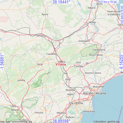
Villena GPS coordinates[2]
38° 38' 14.28" North, 0° 51' 56.448" West
| Map corner | latitude | longitude |
|---|---|---|
| Upper-left | 39.18441°, | -1.56881° |
| Center: | 38.6373°, | -0.86568° |
| Lower-right: | 38.08598°, | -0.16255° |
| Map W x H: | 122.1×122.1 km | = 75.9×75.9mi |
| max Lat: | 43.74134° ⇑84.7% North |
| Villena: | 38.6373° |
| min Lat: | ⇓15.3% South 27.64134° |
| min Long | Villena | max Long |
| -18.00367° | -0.86568° | 4.2899° |
| W 78.2%⇐ | ⇒21.8% E |
Elevation
Elevation of Villena is 525 m = 1722 ft, and this is 73 m = 240 ft below average elevation for this country.
| Max E: |
1682 m = 5518 ft | 60.2% |
| Avg. | 598 m = 1962 ft | |
| Villena | 525 m = 1722 ft | |
Min E: |
0 m = 0 ft | 39.8% |
See also: Spain elevation on elevation.city.
Geographical zone
Villena is located in North temperate zone (between Tropic of Cancer and the Arctic Circle). Distance of this Northern Tropic circle is 1690.1 km =1050.2 mi to South.| Distance of | km | miles | from Villena |
|---|---|---|---|
| North Pole | 5711 | 3548.6 | to North |
| Arctic Circle | 3105.1 | 1929.4 | to North |
| Tropic Cancer | 1690.1 | 1050.2 | to South |
| Equator | 4296.1 | 2669.5 | to South |


Nearby cities:
15 places around Villena: (largest is in red/bold)
• Beneixama
11.1 km =6.9 mi,  50°
50°
• Biar
8.8 km =5.5 mi,  94°
94°
• Bocairent
26 km =16.2 mi,  56°
56°
• Castalla
17.4 km =10.8 mi,  104°
104°
• Caudete
13.1 km =8.1 mi,  306°
306°
• Cañada
6.1 km =3.8 mi, 48°
• Elda
18.9 km =11.7 mi,  160°
160°
• Fontanars dels Alforins
17.7 km =11 mi,  22°
22°
• Ibi
25.5 km =15.8 mi, 92°
• La Font de la Figuera
18.2 km =11.3 mi,  355°
355°
• Monóvar
22.3 km =13.9 mi,  174°
174°
• Onil
16.8 km =10.4 mi, 94°
• Salinas
13.6 km =8.5 mi,  197°
197°
• Sax
11.9 km =7.4 mi, 159°
• Yecla
21.8 km =13.5 mi,  263°
263°
Sources, notices
• [Note1] Compared only with cities in Spain existing in our database
• [Src1] Map data: © OpenStreetMap contributors (CC-BY-SA)
• [Src2] Other city data from geonames.org with taken over terms of usage.
• [Src3] Geographical zone / Annual Mean Temperature by Robert A. Rohde @ Wikipedia
