Campillos geodata
Campillos (Andalusia) is a seat of a third-order administrative division; located in Spain in Europe/Madrid (GMT+2) time zone. With population of 8,014 people, there are 935 cities with bigger population in this country. Compared to other cities in Spain, 95% of cities are located further ↑North; 70.7% of cities are located further →East and 64.2% of cities have higher elevation than Campillos. Note1


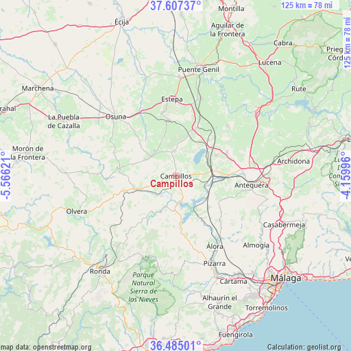
Campillos GPS coordinates[2]
37° 2' 53.736" North, 4° 51' 47.088" West
| Map corner | latitude | longitude |
|---|---|---|
| Upper-left | 37.60737°, | -5.56621° |
| Center: | 37.04826°, | -4.86308° |
| Lower-right: | 36.48501°, | -4.15996° |
| Map W x H: | 124.8×124.8 km | = 77.5×77.5mi |
| max Lat: | 43.74134° ⇑95% North |
| Campillos: | 37.04826° |
| min Lat: | ⇓5% South 27.64134° |
| min Long | Campillos | max Long |
| -18.00367° | -4.86308° | 4.2899° |
| W 29.3%⇐ | ⇒70.7% E |
Elevation
Elevation of Campillos is 470 m = 1542 ft, and this is 128 m = 420 ft below average elevation for this country.
| Max E: |
1682 m = 5518 ft | 64.2% |
| Avg. | 598 m = 1962 ft | |
| Campillos | 470 m = 1542 ft | |
Min E: |
0 m = 0 ft | 35.8% |
See also: Spain elevation on elevation.city.
Geographical zone
Campillos is located in North temperate zone (between Tropic of Cancer and the Arctic Circle). Distance of this Northern Tropic circle is 1513.5 km =940.4 mi to South.| Distance of | km | miles | from Campillos |
|---|---|---|---|
| North Pole | 5887.7 | 3658.4 | to North |
| Arctic Circle | 3281.8 | 2039.2 | to North |
| Tropic Cancer | 1513.5 | 940.4 | to South |
| Equator | 4119.4 | 2559.7 | to South |


Nearby cities:
15 places around Campillos: (largest is in red/bold)
• Almargen
15 km =9.3 mi,  249°
249°
• Ardales
19 km =11.8 mi,  175°
175°
• Carratraca
22.1 km =13.7 mi,  170°
170°
• Cañete la Real
17.9 km =11.1 mi,  233°
233°
• El Saucejo
21 km =13 mi,  277°
277°
• Fuente de Piedra
15.3 km =9.5 mi,  50°
50°
• Humilladero
16 km =9.9 mi,  62°
62°
• La Roda de Andalucía
18.9 km =11.7 mi,  23°
23°
• Los Corrales
12.2 km =7.6 mi,  297°
297°
• Martín de la Jara
11.2 km =7 mi,  307°
307°
• Mollina
20.2 km =12.6 mi, 64°
• Pedrera
20 km =12.4 mi,  352°
352°
• Serrato
20.9 km =13 mi,  210°
210°
• Sierra de Yeguas
8.5 km =5.3 mi,  357°
357°
• Teba
8.7 km =5.4 mi, 214°
Sources, notices
• [Note1] Compared only with cities in Spain existing in our database
• [Src1] Map data: © OpenStreetMap contributors (CC-BY-SA)
• [Src2] Other city data from geonames.org with taken over terms of usage.
• [Src3] Geographical zone / Annual Mean Temperature by Robert A. Rohde @ Wikipedia
