Teba geodata
Teba (Andalusia) is a seat of a third-order administrative division; located in Spain in Europe/Madrid (GMT+2) time zone. With population of 4,304 people, there are 1419 cities with bigger population in this country. Compared to other cities in Spain, 95.5% of cities are located further ↑North; 71.4% of cities are located further →East and 58.5% of cities have higher elevation than Teba. Note1


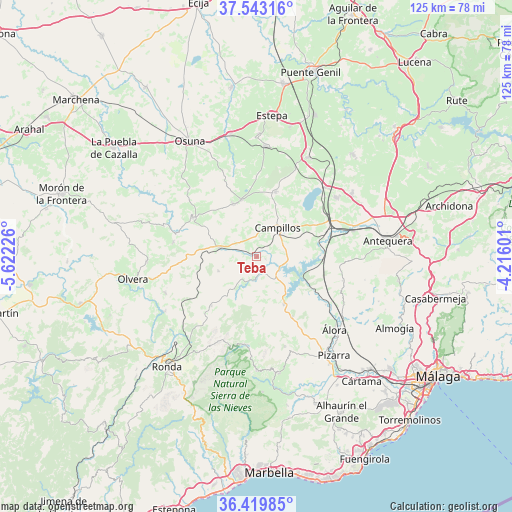
Teba GPS coordinates[2]
36° 59' 0.888" North, 4° 55' 8.868" West
| Map corner | latitude | longitude |
|---|---|---|
| Upper-left | 37.54316°, | -5.62226° |
| Center: | 36.98358°, | -4.91913° |
| Lower-right: | 36.41985°, | -4.21601° |
| Map W x H: | 124.9×124.9 km | = 77.6×77.6mi |
| max Lat: | 43.74134° ⇑95.5% North |
| Teba: | 36.98358° |
| min Lat: | ⇓4.5% South 27.64134° |
| min Long | Teba | max Long |
| -18.00367° | -4.91913° | 4.2899° |
| W 28.6%⇐ | ⇒71.4% E |
Elevation
Elevation of Teba is 547 m = 1795 ft, and this is 51 m = 167 ft below average elevation for this country.
| Max E: |
1682 m = 5518 ft | 58.5% |
| Avg. | 598 m = 1962 ft | |
| Teba | 547 m = 1795 ft | |
Min E: |
0 m = 0 ft | 41.5% |
See also: Spain elevation on elevation.city.
Geographical zone
Teba is located in North temperate zone (between Tropic of Cancer and the Arctic Circle). Distance of this Northern Tropic circle is 1506.3 km =936 mi to South.| Distance of | km | miles | from Teba |
|---|---|---|---|
| North Pole | 5894.9 | 3662.9 | to North |
| Arctic Circle | 3289 | 2043.7 | to North |
| Tropic Cancer | 1506.3 | 936 | to South |
| Equator | 4112.2 | 2555.2 | to South |


Nearby cities:
15 places around Teba: (largest is in red/bold)
• Algámitas
20.8 km =12.9 mi,  279°
279°
• Almargen
9.3 km =5.8 mi, 282°
• Ardales
13.4 km =8.3 mi,  151°
151°
• Campillos
8.7 km =5.4 mi,  34°
34°
• Carratraca
17 km =10.6 mi, 148°
• Casarabonela
23 km =14.3 mi,  162°
162°
• Cañete la Real
10 km =6.2 mi,  249°
249°
• Cuevas del Becerro
16.4 km =10.2 mi,  222°
222°
• El Saucejo
18.7 km =11.6 mi,  301°
301°
• Fuente de Piedra
23.8 km =14.8 mi,  44°
44°
• Los Corrales
14.1 km =8.8 mi,  335°
335°
• Martín de la Jara
14.5 km =9 mi, 344°
• Serrato
12.2 km =7.6 mi,  206°
206°
• Sierra de Yeguas
16.3 km =10.1 mi,  16°
16°
• Villanueva de San Juan
23.9 km =14.9 mi,  287°
287°
Sources, notices
• [Note1] Compared only with cities in Spain existing in our database
• [Src1] Map data: © OpenStreetMap contributors (CC-BY-SA)
• [Src2] Other city data from geonames.org with taken over terms of usage.
• [Src3] Geographical zone / Annual Mean Temperature by Robert A. Rohde @ Wikipedia
