Cáceres geodata
Cáceres (Extremadura) is a seat of a second-order administrative division; located in Spain in Europe/Madrid (GMT+2) time zone. With population of 93,131 people, there are 95 cities with bigger population in this country. Compared to other cities in Spain, 77.1% of cities are located further ↑North; 90.1% of cities are located further →East and 66.4% of cities have higher elevation than Cáceres. Note1


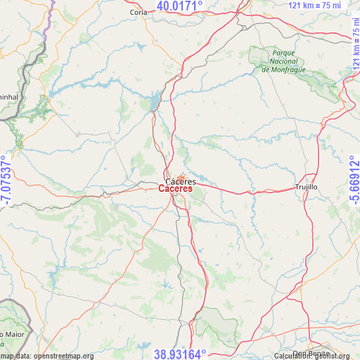
Cáceres GPS coordinates[2]
39° 28' 35.364" North, 6° 22' 20.064" West
| Map corner | latitude | longitude |
|---|---|---|
| Upper-left | 40.0171°, | -7.07537° |
| Center: | 39.47649°, | -6.37224° |
| Lower-right: | 38.93164°, | -5.66912° |
| Map W x H: | 120.7×120.7 km | = 75×75mi |
| max Lat: | 43.74134° ⇑77.1% North |
| Cáceres: | 39.47649° |
| min Lat: | ⇓22.9% South 27.64134° |
| min Long | Cáceres | max Long |
| -18.00367° | -6.37224° | 4.2899° |
| W 9.9%⇐ | ⇒90.1% E |
Elevation
Elevation of Cáceres is 441 m = 1447 ft, and this is 157 m = 515 ft below average elevation for this country.
| Max E: |
1682 m = 5518 ft | 66.4% |
| Avg. | 598 m = 1962 ft | |
| Cáceres | 441 m = 1447 ft | |
Min E: |
0 m = 0 ft | 33.6% |
See also: Cáceres elevation on elevation.city.
Geographical zone
Cáceres is located in North temperate zone (between Tropic of Cancer and the Arctic Circle). Distance of this Northern Tropic circle is 1783.5 km =1108.2 mi to South.| Distance of | km | miles | from Cáceres |
|---|---|---|---|
| North Pole | 5617.7 | 3490.7 | to North |
| Arctic Circle | 3011.8 | 1871.4 | to North |
| Tropic Cancer | 1783.5 | 1108.2 | to South |
| Equator | 4389.4 | 2727.4 | to South |


Nearby cities:
15 places around Cáceres: (largest is in red/bold)
• Aldea del Cano
21.4 km =13.3 mi,  167°
167°
• Arroyo de la Luz
18.2 km =11.3 mi,  273°
273°
• Casar de Cáceres
10.2 km =6.3 mi,  336°
336°
• Casas de Don Antonio
27.7 km =17.2 mi, 165°
• Hinojal
25.9 km =16.1 mi,  3°
3°
• Malpartida de Cáceres
12.1 km =7.5 mi,  254°
254°
• Monroy
22.7 km =14.1 mi,  38°
38°
• Santa Marta de Magasca
23.8 km =14.8 mi,  80°
80°
• Santiago del Campo
16.9 km =10.5 mi, 2°
• Sierra de Fuentes
9.5 km =5.9 mi,  115°
115°
• Talaván
27.9 km =17.3 mi,  16°
16°
• Torremocha
22.4 km =13.9 mi,  130°
130°
• Torreorgaz
14.8 km =9.2 mi, 134°
• Torrequemada
17.9 km =11.1 mi, 133°
• Valdesalor
11.2 km =7 mi, 169°
Sources, notices
• [Note1] Compared only with cities in Spain existing in our database
• [Src1] Map data: © OpenStreetMap contributors (CC-BY-SA)
• [Src2] Other city data from geonames.org with taken over terms of usage.
• [Src3] Geographical zone / Annual Mean Temperature by Robert A. Rohde @ Wikipedia
