Hinojal geodata
Hinojal (Extremadura) is a seat of a third-order administrative division; located in Spain in Europe/Madrid (GMT+2) time zone. With population of 458 people, there are 3988 cities with bigger population in this country. Compared to other cities in Spain, 74.3% of cities are located further ↑North; 90% of cities are located further →East and 72.6% of cities have higher elevation than Hinojal. Note1


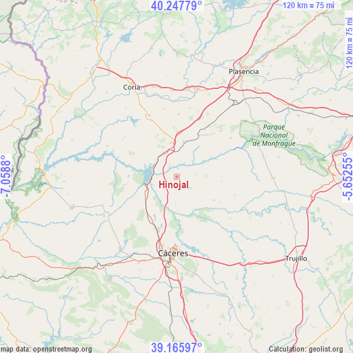
Hinojal GPS coordinates[2]
39° 42' 32.4" North, 6° 21' 20.412" West
| Map corner | latitude | longitude |
|---|---|---|
| Upper-left | 40.24779°, | -7.0588° |
| Center: | 39.709°, | -6.35567° |
| Lower-right: | 39.16597°, | -5.65255° |
| Map W x H: | 120.3×120.3 km | = 74.8×74.8mi |
| max Lat: | 43.74134° ⇑74.3% North |
| Hinojal: | 39.709° |
| min Lat: | ⇓25.7% South 27.64134° |
| min Long | Hinojal | max Long |
| -18.00367° | -6.35567° | 4.2899° |
| W 10%⇐ | ⇒90% E |
Elevation
Elevation of Hinojal is 337 m = 1106 ft, and this is 261 m = 856 ft below average elevation for this country.
| Max E: |
1682 m = 5518 ft | 72.6% |
| Avg. | 598 m = 1962 ft | |
| Hinojal | 337 m = 1106 ft | |
Min E: |
0 m = 0 ft | 27.4% |
See also: Spain elevation on elevation.city.
Geographical zone
Hinojal is located in North temperate zone (between Tropic of Cancer and the Arctic Circle). Distance of this Northern Tropic circle is 1809.3 km =1124.2 mi to South.| Distance of | km | miles | from Hinojal |
|---|---|---|---|
| North Pole | 5591.8 | 3474.6 | to North |
| Arctic Circle | 2985.9 | 1855.4 | to North |
| Tropic Cancer | 1809.3 | 1124.2 | to South |
| Equator | 4415.2 | 2743.5 | to South |


Nearby cities:
15 places around Hinojal: (largest is in red/bold)
• Casar de Cáceres
17.3 km =10.7 mi,  198°
198°
• Casas de Millán
12.3 km =7.6 mi,  10°
10°
• Cañaveral
9.7 km =6 mi,  341°
341°
• Cáceres
25.9 km =16.1 mi,  183°
183°
• Garrovillas
16.7 km =10.4 mi,  270°
270°
• Holguera
21.1 km =13.1 mi,  1°
1°
• Mirabel
20 km =12.4 mi,  31°
31°
• Monroy
14.9 km =9.3 mi,  122°
122°
• Pedroso de Acim
13.8 km =8.6 mi, 339°
• Portezuelo
15.3 km =9.5 mi,  318°
318°
• Ríolobos
24 km =14.9 mi, 10°
• Santiago del Campo
9 km =5.6 mi, 184°
• Serradilla
22.7 km =14.1 mi,  54°
54°
• Talaván
6.4 km =4 mi,  81°
81°
• Torrejoncillo
22.9 km =14.2 mi, 335°
Sources, notices
• [Note1] Compared only with cities in Spain existing in our database
• [Src1] Map data: © OpenStreetMap contributors (CC-BY-SA)
• [Src2] Other city data from geonames.org with taken over terms of usage.
• [Src3] Geographical zone / Annual Mean Temperature by Robert A. Rohde @ Wikipedia
