Bolbaite geodata
Bolbaite (Valencia) is a populated place; located in Spain in Europe/Madrid (GMT+2) time zone. With population of 1,458 people, there are 2501 cities with bigger population in this country. Compared to other cities in Spain, 80.5% of cities are located further ↑North; 80.1% of cities are located further ←West and 78.9% of cities have higher elevation than Bolbaite. Note1


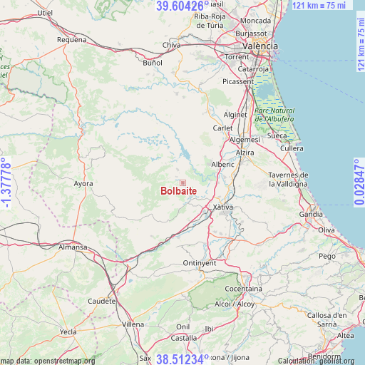
Bolbaite GPS coordinates[2]
39° 3' 37.476" North, 0° 40' 28.776" West
| Map corner | latitude | longitude |
|---|---|---|
| Upper-left | 39.60426°, | -1.37778° |
| Center: | 39.06041°, | -0.67466° |
| Lower-right: | 38.51234°, | 0.02847° |
| Map W x H: | 121.4×121.4 km | = 75.4×75.4mi |
| max Lat: | 43.74134° ⇑80.5% North |
| Bolbaite: | 39.06041° |
| min Lat: | ⇓19.5% South 27.64134° |
| min Long | Bolbaite | max Long |
| -18.00367° | -0.67466° | 4.2899° |
| W 80.1%⇐ | ⇒19.9% E |
Elevation
Elevation of Bolbaite is 239 m = 784 ft, and this is 359 m = 1178 ft below average elevation for this country.
| Max E: |
1682 m = 5518 ft | 78.9% |
| Avg. | 598 m = 1962 ft | |
| Bolbaite | 239 m = 784 ft | |
Min E: |
0 m = 0 ft | 21.1% |
See also: Spain elevation on elevation.city.
Geographical zone
Bolbaite is located in North temperate zone (between Tropic of Cancer and the Arctic Circle). Distance of this Northern Tropic circle is 1737.2 km =1079.4 mi to South.| Distance of | km | miles | from Bolbaite |
|---|---|---|---|
| North Pole | 5664 | 3519.4 | to North |
| Arctic Circle | 3058.1 | 1900.2 | to North |
| Tropic Cancer | 1737.2 | 1079.4 | to South |
| Equator | 4343.1 | 2698.7 | to South |


Nearby cities:
15 places around Bolbaite: (largest is in red/bold)
• Alcàntera de Xúquer
10.8 km =6.7 mi,  86°
86°
• Anna
5.1 km =3.2 mi,  151°
151°
• Antella
7.5 km =4.7 mi,  73°
73°
• Beneixida
10.8 km =6.7 mi, 86°
• Chella
2.4 km =1.5 mi, 146°
• Cotes
8.7 km =5.4 mi,  82°
82°
• Càrcer
9.3 km =5.8 mi, 85°
• Enguera
9 km =5.6 mi,  186°
186°
• Estubeny
6.5 km =4 mi,  137°
137°
• Gavarda
11.1 km =6.9 mi, 76°
• Llanera de Ranes
11.2 km =7 mi,  130°
130°
• Navarrés
4.9 km =3 mi,  339°
339°
• Quesa
8.7 km =5.4 mi,  319°
319°
• Sellent
8.1 km =5 mi,  112°
112°
• Sumacàrcer
5.7 km =3.5 mi,  39°
39°
Sources, notices
• [Note1] Compared only with cities in Spain existing in our database
• [Src1] Map data: © OpenStreetMap contributors (CC-BY-SA)
• [Src2] Other city data from geonames.org with taken over terms of usage.
• [Src3] Geographical zone / Annual Mean Temperature by Robert A. Rohde @ Wikipedia
