Quesa geodata
Quesa (Valencia) is a seat of a third-order administrative division; located in Spain in Europe/Madrid (GMT+2) time zone. With population of 745 people, there are 3316 cities with bigger population in this country. Compared to other cities in Spain, 80% of cities are located further ↑North; 79.5% of cities are located further ←West and 79.5% of cities have higher elevation than Quesa. Note1


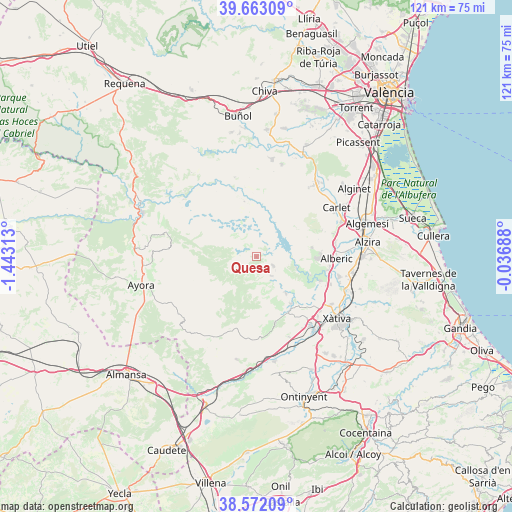
Quesa GPS coordinates[2]
39° 7' 10.92" North, 0° 44' 24" West
| Map corner | latitude | longitude |
|---|---|---|
| Upper-left | 39.66309°, | -1.44313° |
| Center: | 39.1197°, | -0.74° |
| Lower-right: | 38.57209°, | -0.03688° |
| Map W x H: | 121.3×121.3 km | = 75.4×75.4mi |
| max Lat: | 43.74134° ⇑80% North |
| Quesa: | 39.1197° |
| min Lat: | ⇓20% South 27.64134° |
| min Long | Quesa | max Long |
| -18.00367° | -0.74° | 4.2899° |
| W 79.5%⇐ | ⇒20.5% E |
Elevation
Elevation of Quesa is 228 m = 748 ft, and this is 370 m = 1214 ft below average elevation for this country.
| Max E: |
1682 m = 5518 ft | 79.5% |
| Avg. | 598 m = 1962 ft | |
| Quesa | 228 m = 748 ft | |
Min E: |
0 m = 0 ft | 20.5% |
See also: Spain elevation on elevation.city.
Geographical zone
Quesa is located in North temperate zone (between Tropic of Cancer and the Arctic Circle). Distance of this Northern Tropic circle is 1743.8 km =1083.5 mi to South.| Distance of | km | miles | from Quesa |
|---|---|---|---|
| North Pole | 5657.4 | 3515.3 | to North |
| Arctic Circle | 3051.5 | 1896.1 | to North |
| Tropic Cancer | 1743.8 | 1083.5 | to South |
| Equator | 4349.7 | 2702.8 | to South |


Nearby cities:
15 places around Quesa: (largest is in red/bold)
• Anna
13.7 km =8.5 mi,  143°
143°
• Antella
13.5 km =8.4 mi,  109°
109°
• Bicorp
4.3 km =2.7 mi,  288°
288°
• Bolbaite
8.7 km =5.4 mi, 139°
• Chella
11.1 km =6.9 mi, 141°
• Cotes
15.3 km =9.5 mi, 111°
• Càrcer
16.1 km =10 mi, 111°
• Enguera
16.2 km =10.1 mi,  163°
163°
• Estubeny
15.1 km =9.4 mi, 138°
• Gavarda
16.9 km =10.5 mi,  103°
103°
• Millares
14.7 km =9.1 mi,  350°
350°
• Navarrés
4.4 km =2.7 mi,  116°
116°
• Sellent
16.3 km =10.1 mi,  126°
126°
• Sumacàrcer
9.5 km =5.9 mi, 103°
• Tous
13.3 km =8.3 mi,  80°
80°
Sources, notices
• [Note1] Compared only with cities in Spain existing in our database
• [Src1] Map data: © OpenStreetMap contributors (CC-BY-SA)
• [Src2] Other city data from geonames.org with taken over terms of usage.
• [Src3] Geographical zone / Annual Mean Temperature by Robert A. Rohde @ Wikipedia
