Cabezas Rubias geodata
Cabezas Rubias (Andalusia) is a seat of a third-order administrative division; located in Spain in Europe/Madrid (GMT+2) time zone. With population of 873 people, there are 3097 cities with bigger population in this country. Compared to other cities in Spain, 89.9% of cities are located further ↑North; 94.5% of cities are located further →East and 79.9% of cities have higher elevation than Cabezas Rubias. Note1


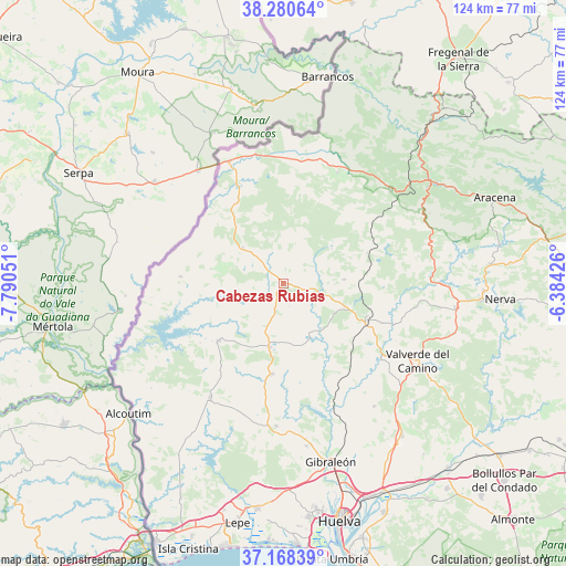
Cabezas Rubias GPS coordinates[2]
37° 43' 35.76" North, 7° 5' 14.568" West
| Map corner | latitude | longitude |
|---|---|---|
| Upper-left | 38.28064°, | -7.79051° |
| Center: | 37.7266°, | -7.08738° |
| Lower-right: | 37.16839°, | -6.38426° |
| Map W x H: | 123.7×123.7 km | = 76.9×76.9mi |
| max Lat: | 43.74134° ⇑89.9% North |
| Cabezas Rubias: | 37.7266° |
| min Lat: | ⇓10.1% South 27.64134° |
| min Long | Cabezas Rubias | max Long |
| -18.00367° | -7.08738° | 4.2899° |
| W 5.5%⇐ | ⇒94.5% E |
Elevation
Elevation of Cabezas Rubias is 222 m = 728 ft, and this is 376 m = 1234 ft below average elevation for this country.
| Max E: |
1682 m = 5518 ft | 79.9% |
| Avg. | 598 m = 1962 ft | |
| Cabezas Rubias | 222 m = 728 ft | |
Min E: |
0 m = 0 ft | 20.1% |
See also: Spain elevation on elevation.city.
Geographical zone
Cabezas Rubias is located in North temperate zone (between Tropic of Cancer and the Arctic Circle). Distance of this Northern Tropic circle is 1588.9 km =987.3 mi to South.| Distance of | km | miles | from Cabezas Rubias |
|---|---|---|---|
| North Pole | 5812.3 | 3611.6 | to North |
| Arctic Circle | 3206.4 | 1992.4 | to North |
| Tropic Cancer | 1588.9 | 987.3 | to South |
| Equator | 4194.8 | 2606.5 | to South |


Nearby cities:
15 places around Cabezas Rubias: (largest is in red/bold)
• Alosno
19.9 km =12.4 mi,  186°
186°
• Aroche
26.5 km =16.5 mi,  25°
25°
• Calañas
19.8 km =12.3 mi,  113°
113°
• Cortegana
31.2 km =19.4 mi,  48°
48°
• El Cerro de Andévalo
13.3 km =8.3 mi,  85°
85°
• El Granado
37 km =23 mi,  231°
231°
• Paymogo
22.7 km =14.1 mi,  273°
273°
• Puebla de Guzmán
18.9 km =11.7 mi, 228°
• Rosal de la Frontera
29.2 km =18.1 mi,  336°
336°
• San Bartolomé de la Torre
31.3 km =19.4 mi,  182°
182°
• Santa Ana la Real
35.3 km =21.9 mi,  64°
64°
• Santa Bárbara de Casa
11.7 km =7.3 mi,  311°
311°
• Valverde del Camino
33.8 km =21 mi,  119°
119°
• Villanueva de las Cruces
12.3 km =7.6 mi,  152°
152°
• Villanueva de los Castillejos
31 km =19.3 mi,  215°
215°
Sources, notices
• [Note1] Compared only with cities in Spain existing in our database
• [Src1] Map data: © OpenStreetMap contributors (CC-BY-SA)
• [Src2] Other city data from geonames.org with taken over terms of usage.
• [Src3] Geographical zone / Annual Mean Temperature by Robert A. Rohde @ Wikipedia
