Arenas de San Juan geodata
Arenas de San Juan (Castille-La Mancha) is a seat of a third-order administrative division; located in Spain in Europe/Madrid (GMT+2) time zone. With population of 1,083 people, there are 2841 cities with bigger population in this country. Compared to other cities in Spain, 79.3% of cities are located further ↑North; 52.2% of cities are located further →East and 52.6% of cities have higher elevation than Arenas de San Juan. Note1
Administrative division(s):
- Level 1: Castille-La Mancha
- Level 2: Provincia de Ciudad Real
- Level 3: Arenas de San Juan


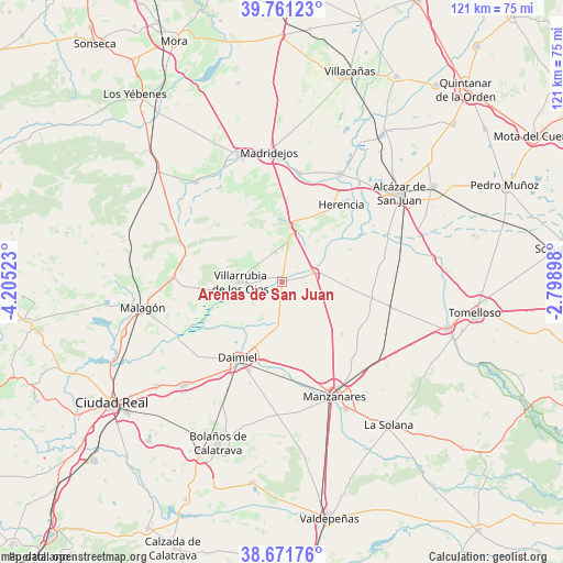
Arenas de San Juan GPS coordinates[2]
39° 13' 6.996" North, 3° 30' 7.596" West
| Map corner | latitude | longitude |
|---|---|---|
| Upper-left | 39.76123°, | -4.20523° |
| Center: | 39.21861°, | -3.50211° |
| Lower-right: | 38.67176°, | -2.79898° |
| Map W x H: | 121.1×121.1 km | = 75.2×75.2mi |
| max Lat: | 43.74134° ⇑79.3% North |
| Arenas de San Juan: | 39.21861° |
| min Lat: | ⇓20.7% South 27.64134° |
| min Long | Arenas de San J | max Long |
| -18.00367° | -3.50211° | 4.2899° |
| W 47.8%⇐ | ⇒52.2% E |
Elevation
Elevation of Arenas de San Juan is 629 m = 2064 ft, and this is 31 m = 102 ft above average elevation for this country.
| Max E: |
1682 m = 5518 ft | 52.6% |
| Arenas de San Juan | 629 m 2064 ft | |
| Avg. | 598 m = 1962 ft | |
Min E: |
0 m = 0 ft | 47.4% |
See also: Spain elevation on elevation.city.
Geographical zone
Arenas de San Juan is located in North temperate zone (between Tropic of Cancer and the Arctic Circle). Distance of this Northern Tropic circle is 1754.8 km =1090.4 mi to South.| Distance of | km | miles | from Arenas de San Juan |
|---|---|---|---|
| North Pole | 5646.4 | 3508.5 | to North |
| Arctic Circle | 3040.5 | 1889.3 | to North |
| Tropic Cancer | 1754.8 | 1090.4 | to South |
| Equator | 4360.7 | 2709.6 | to South |


Nearby cities:
15 places around Arenas de San Juan: (largest is in red/bold)
• Camuñas
23.5 km =14.6 mi,  9°
9°
• Consuegra
28.6 km =17.8 mi,  341°
341°
• Daimiel
19.2 km =11.9 mi,  210°
210°
• Fuente el Fresno
23.5 km =14.6 mi,  272°
272°
• Herencia
20.6 km =12.8 mi,  37°
37°
• Las Labores
6.4 km =4 mi,  347°
347°
• Llanos del Caudillo
17.1 km =10.6 mi,  130°
130°
• Madridejos
27.9 km =17.3 mi, 354°
• Manzanares
26.9 km =16.7 mi,  154°
154°
• Membrilla
30.7 km =19.1 mi, 153°
• Puerto Lápice
11.8 km =7.3 mi, 8°
• Urda
28.2 km =17.5 mi,  319°
319°
• Villafranca de los Caballeros
26.3 km =16.3 mi,  27°
27°
• Villarrubia de los Ojos
9.1 km =5.7 mi, 271°
• Villarta de San Juan
7.1 km =4.4 mi,  72°
72°
Sources, notices
• [Note1] Compared only with cities in Spain existing in our database
• [Src1] Map data: © OpenStreetMap contributors (CC-BY-SA)
• [Src2] Other city data from geonames.org with taken over terms of usage.
• [Src3] Geographical zone / Annual Mean Temperature by Robert A. Rohde @ Wikipedia
