Consuegra geodata
Consuegra (Castille-La Mancha) is a seat of a third-order administrative division; located in Spain in Europe/Madrid (GMT+2) time zone. With population of 10,932 people, there are 807 cities with bigger population in this country. Compared to other cities in Spain, 77.3% of cities are located further ↑North; 53.8% of cities are located further →East and 54.8% of cities have lower elevation than Consuegra. Note1
Administrative division(s):
- Level 1: Castille-La Mancha
- Level 2: Province of Toledo
- Level 3: Consuegra


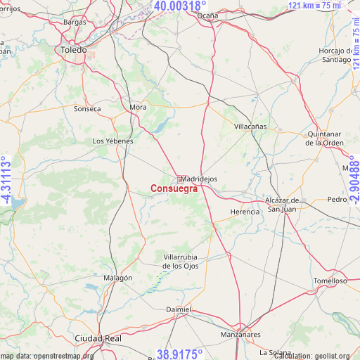
Consuegra GPS coordinates[2]
39° 27' 44.856" North, 3° 36' 28.8" West
| Map corner | latitude | longitude |
|---|---|---|
| Upper-left | 40.00318°, | -4.31113° |
| Center: | 39.46246°, | -3.608° |
| Lower-right: | 38.9175°, | -2.90488° |
| Map W x H: | 120.7×120.7 km | = 75×75mi |
| max Lat: | 43.74134° ⇑77.3% North |
| Consuegra: | 39.46246° |
| min Lat: | ⇓22.7% South 27.64134° |
| min Long | Consuegra | max Long |
| -18.00367° | -3.608° | 4.2899° |
| W 46.2%⇐ | ⇒53.8% E |
Elevation
Elevation of Consuegra is 708 m = 2323 ft, and this is 110 m = 361 ft above average elevation for this country.
| Max E: |
1682 m = 5518 ft | 45.2% |
| Consuegra | 708 m 2323 ft | |
| Avg. | 598 m = 1962 ft | |
Min E: |
0 m = 0 ft | 54.8% |
See also: Spain elevation on elevation.city.
Geographical zone
Consuegra is located in North temperate zone (between Tropic of Cancer and the Arctic Circle). Distance of this Northern Tropic circle is 1781.9 km =1107.2 mi to South.| Distance of | km | miles | from Consuegra |
|---|---|---|---|
| North Pole | 5619.2 | 3491.6 | to North |
| Arctic Circle | 3013.4 | 1872.4 | to North |
| Tropic Cancer | 1781.9 | 1107.2 | to South |
| Equator | 4387.8 | 2726.5 | to South |


Nearby cities:
15 places around Consuegra: (largest is in red/bold)
• Arenas de San Juan
28.6 km =17.8 mi,  161°
161°
• Camuñas
13.7 km =8.5 mi,  106°
106°
• Herencia
24 km =14.9 mi,  116°
116°
• Las Labores
22.3 km =13.9 mi, 159°
• Los Yébenes
26.1 km =16.2 mi,  300°
300°
• Madridejos
6.6 km =4.1 mi,  84°
84°
• Manzaneque
24.9 km =15.5 mi,  320°
320°
• Mora
28.5 km =17.7 mi,  330°
330°
• Puerto Lápice
18.9 km =11.7 mi,  144°
144°
• Tembleque
27.4 km =17 mi,  18°
18°
• Turleque
15.5 km =9.6 mi,  358°
358°
• Urda
10.8 km =6.7 mi,  238°
238°
• Villacañas
29.3 km =18.2 mi,  52°
52°
• Villafranca de los Caballeros
21.6 km =13.4 mi,  100°
100°
• Villarrubia de los Ojos
26.9 km =16.7 mi,  180°
180°
Sources, notices
• [Note1] Compared only with cities in Spain existing in our database
• [Src1] Map data: © OpenStreetMap contributors (CC-BY-SA)
• [Src2] Other city data from geonames.org with taken over terms of usage.
• [Src3] Geographical zone / Annual Mean Temperature by Robert A. Rohde @ Wikipedia
