Bailén geodata
Bailén (Andalusia) is a seat of a third-order administrative division; located in Spain in Europe/Madrid (GMT+2) time zone. With population of 18,785 people, there are 500 cities with bigger population in this country. Compared to other cities in Spain, 87.8% of cities are located further ↑North; 56.5% of cities are located further →East and 71.9% of cities have higher elevation than Bailén. Note1


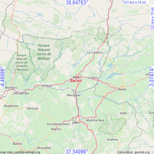
Bailén GPS coordinates[2]
38° 5' 47.004" North, 3° 46' 40.296" West
| Map corner | latitude | longitude |
|---|---|---|
| Upper-left | 38.64763°, | -4.48099° |
| Center: | 38.09639°, | -3.77786° |
| Lower-right: | 37.54096°, | -3.07474° |
| Map W x H: | 123.1×123.1 km | = 76.5×76.5mi |
| max Lat: | 43.74134° ⇑87.8% North |
| Bailén: | 38.09639° |
| min Lat: | ⇓12.2% South 27.64134° |
| min Long | Bailén | max Long |
| -18.00367° | -3.77786° | 4.2899° |
| W 43.5%⇐ | ⇒56.5% E |
Elevation
Elevation of Bailén is 349 m = 1145 ft, and this is 249 m = 817 ft below average elevation for this country.
| Max E: |
1682 m = 5518 ft | 71.9% |
| Avg. | 598 m = 1962 ft | |
| Bailén | 349 m = 1145 ft | |
Min E: |
0 m = 0 ft | 28.1% |
See also: Spain elevation on elevation.city.
Geographical zone
Bailén is located in North temperate zone (between Tropic of Cancer and the Arctic Circle). Distance of this Northern Tropic circle is 1630 km =1012.8 mi to South.| Distance of | km | miles | from Bailén |
|---|---|---|---|
| North Pole | 5771.1 | 3586 | to North |
| Arctic Circle | 3165.3 | 1966.8 | to North |
| Tropic Cancer | 1630 | 1012.8 | to South |
| Equator | 4235.9 | 2632.1 | to South |


Nearby cities:
15 places around Bailén: (largest is in red/bold)
• Andújar
24.7 km =15.3 mi,  255°
255°
• Baños de la Encina
8.6 km =5.3 mi,  1°
1°
• Begíjar
24.9 km =15.5 mi,  119°
119°
• Carboneros
19.6 km =12.2 mi,  40°
40°
• Cazalilla
15.5 km =9.6 mi,  216°
216°
• Espelúy
10.4 km =6.5 mi,  226°
226°
• Guarromán
12.5 km =7.8 mi, 39°
• Higuera de Arjona
23.3 km =14.5 mi, 233°
• Jabalquinto
9.7 km =6 mi,  151°
151°
• La Carolina
24.5 km =15.2 mi, 35°
• Linares
12.4 km =7.7 mi,  90°
90°
• Lupión
23.1 km =14.4 mi, 118°
• Mengibar
14.3 km =8.9 mi,  190°
190°
• Torreblascopedro
16.5 km =10.3 mi,  131°
131°
• Villanueva de la Reina
15.8 km =9.8 mi, 229°
Sources, notices
• [Note1] Compared only with cities in Spain existing in our database
• [Src1] Map data: © OpenStreetMap contributors (CC-BY-SA)
• [Src2] Other city data from geonames.org with taken over terms of usage.
• [Src3] Geographical zone / Annual Mean Temperature by Robert A. Rohde @ Wikipedia
