Almensilla geodata
Almensilla (Andalusia) is a seat of a third-order administrative division; located in Spain in Europe/Madrid (GMT+2) time zone. With population of 4,883 people, there are 1332 cities with bigger population in this country. Compared to other cities in Spain, 92.9% of cities are located further ↑North; 87.5% of cities are located further →East and 91.1% of cities have higher elevation than Almensilla. Note1


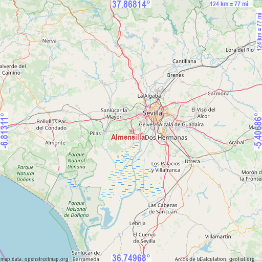
Almensilla GPS coordinates[2]
37° 18' 39.564" North, 6° 6' 35.928" West
| Map corner | latitude | longitude |
|---|---|---|
| Upper-left | 37.86814°, | -6.81311° |
| Center: | 37.31099°, | -6.10998° |
| Lower-right: | 36.74968°, | -5.40686° |
| Map W x H: | 124.4×124.4 km | = 77.3×77.3mi |
| max Lat: | 43.74134° ⇑92.9% North |
| Almensilla: | 37.31099° |
| min Lat: | ⇓7.1% South 27.64134° |
| min Long | Almensilla | max Long |
| -18.00367° | -6.10998° | 4.2899° |
| W 12.5%⇐ | ⇒87.5% E |
Elevation
Elevation of Almensilla is 51 m = 167 ft, and this is 547 m = 1795 ft below average elevation for this country.
| Max E: |
1682 m = 5518 ft | 91.1% |
| Avg. | 598 m = 1962 ft | |
| Almensilla | 51 m = 167 ft | |
Min E: |
0 m = 0 ft | 8.9% |
See also: Spain elevation on elevation.city.
Geographical zone
Almensilla is located in North temperate zone (between Tropic of Cancer and the Arctic Circle). Distance of this Northern Tropic circle is 1542.7 km =958.6 mi to South.| Distance of | km | miles | from Almensilla |
|---|---|---|---|
| North Pole | 5858.5 | 3640.3 | to North |
| Arctic Circle | 3252.6 | 2021.1 | to North |
| Tropic Cancer | 1542.7 | 958.6 | to South |
| Equator | 4148.6 | 2577.8 | to South |


Nearby cities:
15 places around Almensilla: (largest is in red/bold)
• Benacazón
9 km =5.6 mi,  301°
301°
• Bollullos de la Mitación
4 km =2.5 mi,  323°
323°
• Bormujos
7.7 km =4.8 mi,  25°
25°
• Castilleja de la Cuesta
9.8 km =6.1 mi, 31°
• Coria del Río
5.6 km =3.5 mi,  117°
117°
• Espartinas
8 km =5 mi,  349°
349°
• Gelves
7.9 km =4.9 mi,  70°
70°
• Gines
8.9 km =5.5 mi,  18°
18°
• La Puebla del Río
6.4 km =4 mi,  138°
138°
• Mairena del Aljarafe
5.5 km =3.4 mi,  47°
47°
• Palomares del Río
4.7 km =2.9 mi, 74°
• San Juan de Aznalfarache
8.3 km =5.2 mi, 50°
• Tomares
8.9 km =5.5 mi,  39°
39°
• Umbrete
7.7 km =4.8 mi,  326°
326°
• Villanueva del Ariscal
9.9 km =6.2 mi,  343°
343°
Sources, notices
• [Note1] Compared only with cities in Spain existing in our database
• [Src1] Map data: © OpenStreetMap contributors (CC-BY-SA)
• [Src2] Other city data from geonames.org with taken over terms of usage.
• [Src3] Geographical zone / Annual Mean Temperature by Robert A. Rohde @ Wikipedia
