Chóvar geodata
Chóvar (Valencia) is a seat of a third-order administrative division; located in Spain in Europe/Madrid (GMT+2) time zone. With population of 339 people, there are 4351 cities with bigger population in this country. Compared to other cities in Spain, 72.4% of cities are located further ↑North; 84.4% of cities are located further ←West and 68% of cities have higher elevation than Chóvar. Note1


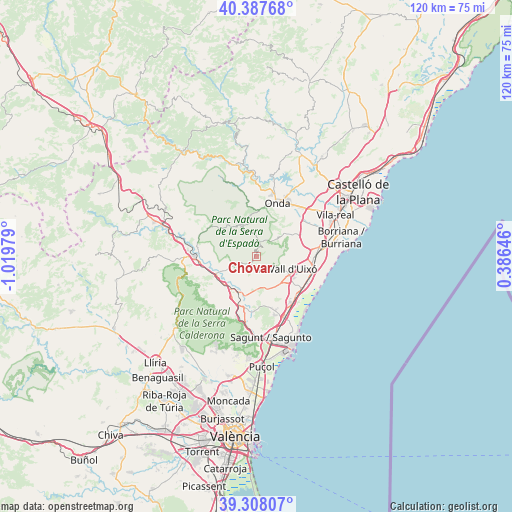
Chóvar GPS coordinates[2]
39° 51' 0" North, 0° 19' 0.012" West
| Map corner | latitude | longitude |
|---|---|---|
| Upper-left | 40.38768°, | -1.01979° |
| Center: | 39.85°, | -0.31667° |
| Lower-right: | 39.30807°, | 0.38646° |
| Map W x H: | 120×120 km | = 74.6×74.6mi |
| max Lat: | 43.74134° ⇑72.4% North |
| Chóvar: | 39.85° |
| min Lat: | ⇓27.6% South 27.64134° |
| min Long | Chóvar | max Long |
| -18.00367° | -0.31667° | 4.2899° |
| W 84.4%⇐ | ⇒15.6% E |
Elevation
Elevation of Chóvar is 417 m = 1368 ft, and this is 181 m = 594 ft below average elevation for this country.
| Max E: |
1682 m = 5518 ft | 68% |
| Avg. | 598 m = 1962 ft | |
| Chóvar | 417 m = 1368 ft | |
Min E: |
0 m = 0 ft | 32% |
See also: Spain elevation on elevation.city.
Geographical zone
Chóvar is located in North temperate zone (between Tropic of Cancer and the Arctic Circle). Distance of this Northern Tropic circle is 1825 km =1134 mi to South.| Distance of | km | miles | from Chóvar |
|---|---|---|---|
| North Pole | 5576.2 | 3464.9 | to North |
| Arctic Circle | 2970.3 | 1845.7 | to North |
| Tropic Cancer | 1825 | 1134 | to South |
| Equator | 4430.9 | 2753.2 | to South |


Nearby cities:
15 places around Chóvar: (largest is in red/bold)
• Alcudia de Veo
7.9 km =4.9 mi,  339°
339°
• Alfara de Algimia
9.7 km =6 mi,  197°
197°
• Alfondeguilla
4.7 km =2.9 mi,  113°
113°
• Algimia de Alfara
11.9 km =7.4 mi, 201°
• Algimia de Almonacid
12.4 km =7.7 mi,  306°
306°
• Almedíjar
7.3 km =4.5 mi,  284°
284°
• Artana
6.8 km =4.2 mi,  47°
47°
• Azuébar
4.7 km =2.9 mi,  246°
246°
• Castellnovo
11.5 km =7.1 mi, 279°
• Eslida
4 km =2.5 mi,  21°
21°
• Soneja
9.3 km =5.8 mi, 246°
• Sot de Ferrer
9 km =5.6 mi,  232°
232°
• Tales
11 km =6.8 mi,  4°
4°
• Vall de Almonacid
12.7 km =7.9 mi,  296°
296°
• Villavieja
11.4 km =7.1 mi,  90°
90°
Sources, notices
• [Note1] Compared only with cities in Spain existing in our database
• [Src1] Map data: © OpenStreetMap contributors (CC-BY-SA)
• [Src2] Other city data from geonames.org with taken over terms of usage.
• [Src3] Geographical zone / Annual Mean Temperature by Robert A. Rohde @ Wikipedia
