Alpera geodata
Alpera (Castille-La Mancha) is a seat of a third-order administrative division; located in Spain in Europe/Madrid (GMT+2) time zone. With population of 2,328 people, there are 1986 cities with bigger population in this country. Compared to other cities in Spain, 81.4% of cities are located further ↑North; 75.4% of cities are located further ←West and 70% of cities have lower elevation than Alpera. Note1
Administrative division(s):
- Level 1: Castille-La Mancha
- Level 2: Provincia de Albacete
- Level 3: Alpera


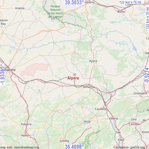
Alpera GPS coordinates[2]
38° 57' 31.176" North, 1° 13' 49.872" West
| Map corner | latitude | longitude |
|---|---|---|
| Upper-left | 39.5033°, | -1.93365° |
| Center: | 38.95866°, | -1.23052° |
| Lower-right: | 38.4098°, | -0.5274° |
| Map W x H: | 121.6×121.6 km | = 75.6×75.6mi |
| max Lat: | 43.74134° ⇑81.4% North |
| Alpera: | 38.95866° |
| min Lat: | ⇓18.6% South 27.64134° |
| min Long | Alpera | max Long |
| -18.00367° | -1.23052° | 4.2899° |
| W 75.4%⇐ | ⇒24.6% E |
Elevation
Elevation of Alpera is 814 m = 2671 ft, and this is 216 m = 709 ft above average elevation for this country.
| Max E: |
1682 m = 5518 ft | 30% |
| Alpera | 814 m 2671 ft | |
| Avg. | 598 m = 1962 ft | |
Min E: |
0 m = 0 ft | 70% |
See also: Spain elevation on elevation.city.
Geographical zone
Alpera is located in North temperate zone (between Tropic of Cancer and the Arctic Circle). Distance of this Northern Tropic circle is 1725.9 km =1072.4 mi to South.| Distance of | km | miles | from Alpera |
|---|---|---|---|
| North Pole | 5675.3 | 3526.5 | to North |
| Arctic Circle | 3069.4 | 1907.2 | to North |
| Tropic Cancer | 1725.9 | 1072.4 | to South |
| Equator | 4331.8 | 2691.7 | to South |


Nearby cities:
15 places around Alpera: (largest is in red/bold)
• Alatoz
18.9 km =11.7 mi,  323°
323°
• Almansa
15.2 km =9.4 mi,  130°
130°
• Ayora
18.7 km =11.6 mi,  53°
53°
• Bonete
14.1 km =8.8 mi,  226°
226°
• Carcelén
17.3 km =10.7 mi,  337°
337°
• Corral-Rubio
24.2 km =15 mi,  235°
235°
• Higueruela
18.4 km =11.4 mi,  271°
271°
• Hoya-Gonzalo
28.2 km =17.5 mi, 269°
• Jarafuel
24.3 km =15.1 mi,  33°
33°
• Montealegre del Castillo
20.7 km =12.9 mi,  203°
203°
• Pozo Lorente
27.2 km =16.9 mi,  298°
298°
• Teresa de Cofrentes
22.5 km =14 mi,  43°
43°
• Villa de Ves
26.8 km =16.7 mi,  359°
359°
• Villavaliente
27 km =16.8 mi,  313°
313°
• Zarra
20 km =12.4 mi, 42°
Sources, notices
• [Note1] Compared only with cities in Spain existing in our database
• [Src1] Map data: © OpenStreetMap contributors (CC-BY-SA)
• [Src2] Other city data from geonames.org with taken over terms of usage.
• [Src3] Geographical zone / Annual Mean Temperature by Robert A. Rohde @ Wikipedia
