Zuñeda geodata
Zuñeda (Castille and León) is a seat of a third-order administrative division; located in Spain in Europe/Madrid (GMT+2) time zone. With population of 61 people, there are 6339 cities with bigger population in this country. Compared to other cities in Spain, 89.6% of cities are located further ↓South; 51.3% of cities are located further ←West and 56.2% of cities have lower elevation than Zuñeda. Note1


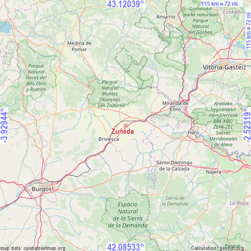
Zuñeda GPS coordinates[2]
42° 36' 18.036" North, 3° 13' 34.752" West
| Map corner | latitude | longitude |
|---|---|---|
| Upper-left | 43.12039°, | -3.92944° |
| Center: | 42.60501°, | -3.22632° |
| Lower-right: | 42.08533°, | -2.52319° |
| Map W x H: | 115.1×115.1 km | = 71.5×71.5mi |
| max Lat: | 43.74134° ⇑10.4% North |
| Zuñeda: | 42.60501° |
| min Lat: | ⇓89.6% South 27.64134° |
| min Long | Zuñeda | max Long |
| -18.00367° | -3.22632° | 4.2899° |
| W 51.3%⇐ | ⇒48.7% E |
Elevation
Elevation of Zuñeda is 717 m = 2352 ft, and this is 119 m = 390 ft above average elevation for this country.
| Max E: |
1682 m = 5518 ft | 43.8% |
| Zuñeda | 717 m 2352 ft | |
| Avg. | 598 m = 1962 ft | |
Min E: |
0 m = 0 ft | 56.2% |
See also: Spain elevation on elevation.city.
Geographical zone
Zuñeda is located in North temperate zone (between Tropic of Cancer and the Arctic Circle). Distance of this Northern Tropic circle is 2131.3 km =1324.3 mi to South.| Distance of | km | miles | from Zuñeda |
|---|---|---|---|
| North Pole | 5269.8 | 3274.5 | to North |
| Arctic Circle | 2663.9 | 1655.3 | to North |
| Tropic Cancer | 2131.3 | 1324.3 | to South |
| Equator | 4737.2 | 2943.6 | to South |


Nearby cities:
15 places around Zuñeda: (largest is in red/bold)
• Aguilar de Bureba
8.6 km =5.3 mi,  258°
258°
• Berzosa de Bureba
4.1 km =2.5 mi,  306°
306°
• Briviesca
10 km =6.2 mi,  232°
232°
• Busto de Bureba
6.8 km =4.2 mi,  332°
332°
• Cascajares de Bureba
8.3 km =5.2 mi,  353°
353°
• Cubo de Bureba
4.2 km =2.6 mi,  22°
22°
• Fuentebureba
3.3 km =2.1 mi, 347°
• Grisaleña
3.5 km =2.2 mi,  243°
243°
• Miraveche
8 km =5 mi, 15°
• Pancorbo
9.9 km =6.2 mi,  70°
70°
• Quintanaélez
9.3 km =5.8 mi,  320°
320°
• Vallarta de Bureba
2.5 km =1.6 mi,  135°
135°
• Valluércanes
9.4 km =5.8 mi,  112°
112°
• Vileña
8.1 km =5 mi,  283°
283°
• Villanueva de Teba
7.1 km =4.4 mi,  46°
46°
Sources, notices
• [Note1] Compared only with cities in Spain existing in our database
• [Src1] Map data: © OpenStreetMap contributors (CC-BY-SA)
• [Src2] Other city data from geonames.org with taken over terms of usage.
• [Src3] Geographical zone / Annual Mean Temperature by Robert A. Rohde @ Wikipedia
