Miraveche geodata
Miraveche (Castille and León) is a seat of a third-order administrative division; located in Spain in Europe/Madrid (GMT+2) time zone. With population of 103 people, there are 5896 cities with bigger population in this country. Compared to other cities in Spain, 91.1% of cities are located further ↓South; 51.6% of cities are located further ←West and 69% of cities have lower elevation than Miraveche. Note1
Administrative division(s):
- Level 1: Castille and León
- Level 2: Provincia de Burgos
- Level 3: Miraveche


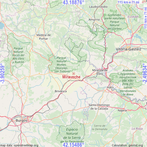
Miraveche GPS coordinates[2]
42° 40' 26.256" North, 3° 11' 58.092" West
| Map corner | latitude | longitude |
|---|---|---|
| Upper-left | 43.18876°, | -3.90259° |
| Center: | 42.67396°, | -3.19947° |
| Lower-right: | 42.15486°, | -2.49634° |
| Map W x H: | 115×115 km | = 71.5×71.5mi |
| max Lat: | 43.74134° ⇑8.9% North |
| Miraveche: | 42.67396° |
| min Lat: | ⇓91.1% South 27.64134° |
| min Long | Miraveche | max Long |
| -18.00367° | -3.19947° | 4.2899° |
| W 51.6%⇐ | ⇒48.4% E |
Elevation
Elevation of Miraveche is 806 m = 2644 ft, and this is 208 m = 682 ft above average elevation for this country.
| Max E: |
1682 m = 5518 ft | 31% |
| Miraveche | 806 m 2644 ft | |
| Avg. | 598 m = 1962 ft | |
Min E: |
0 m = 0 ft | 69% |
See also: Spain elevation on elevation.city.
Geographical zone
Miraveche is located in North temperate zone (between Tropic of Cancer and the Arctic Circle). Distance of this Northern Tropic circle is 2139 km =1329.1 mi to South.| Distance of | km | miles | from Miraveche |
|---|---|---|---|
| North Pole | 5262.2 | 3269.8 | to North |
| Arctic Circle | 2656.3 | 1650.5 | to North |
| Tropic Cancer | 2139 | 1329.1 | to South |
| Equator | 4744.9 | 2948.3 | to South |


Nearby cities:
15 places around Miraveche: (largest is in red/bold)
• Ameyugo
11.4 km =7.1 mi,  99°
99°
• Berzosa de Bureba
7.6 km =4.7 mi,  226°
226°
• Busto de Bureba
5.6 km =3.5 mi,  252°
252°
• Cascajares de Bureba
3.2 km =2 mi,  279°
279°
• Cubo de Bureba
3.8 km =2.4 mi,  188°
188°
• Encío
9.2 km =5.7 mi,  91°
91°
• Fuentebureba
5.3 km =3.3 mi,  213°
213°
• Grisaleña
10.6 km =6.6 mi, 209°
• Navas de Bureba
10.5 km =6.5 mi,  274°
274°
• Pancorbo
8.4 km =5.2 mi,  121°
121°
• Quintanaélez
8.1 km =5 mi, 266°
• Vallarta de Bureba
9.5 km =5.9 mi,  182°
182°
• Vileña
11.6 km =7.2 mi,  240°
240°
• Villanueva de Teba
4.1 km =2.5 mi,  133°
133°
• Zuñeda
8 km =5 mi,  195°
195°
Sources, notices
• [Note1] Compared only with cities in Spain existing in our database
• [Src1] Map data: © OpenStreetMap contributors (CC-BY-SA)
• [Src2] Other city data from geonames.org with taken over terms of usage.
• [Src3] Geographical zone / Annual Mean Temperature by Robert A. Rohde @ Wikipedia
