Fuentebureba geodata
Fuentebureba (Castille and León) is a seat of a third-order administrative division; located in Spain in Europe/Madrid (GMT+2) time zone. With population of 72 people, there are 6222 cities with bigger population in this country. Compared to other cities in Spain, 90.3% of cities are located further ↓South; 51.2% of cities are located further ←West and 52% of cities have lower elevation than Fuentebureba. Note1
Administrative division(s):
- Level 1: Castille and León
- Level 2: Provincia de Burgos
- Level 3: Fuentebureba


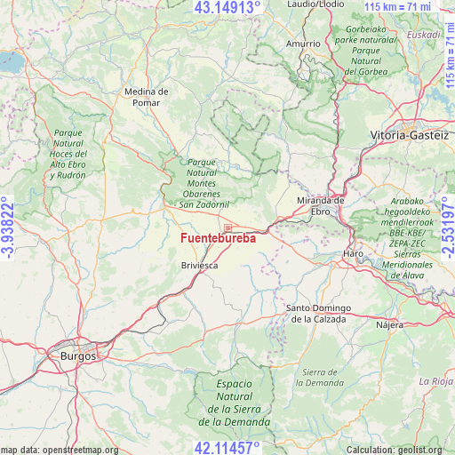
Fuentebureba GPS coordinates[2]
42° 38' 2.4" North, 3° 14' 6.36" West
| Map corner | latitude | longitude |
|---|---|---|
| Upper-left | 43.14913°, | -3.93822° |
| Center: | 42.634°, | -3.2351° |
| Lower-right: | 42.11457°, | -2.53197° |
| Map W x H: | 115×115 km | = 71.5×71.5mi |
| max Lat: | 43.74134° ⇑9.7% North |
| Fuentebureba: | 42.634° |
| min Lat: | ⇓90.3% South 27.64134° |
| min Long | Fuentebureba | max Long |
| -18.00367° | -3.2351° | 4.2899° |
| W 51.2%⇐ | ⇒48.8% E |
Elevation
Elevation of Fuentebureba is 680 m = 2231 ft, and this is 82 m = 269 ft above average elevation for this country.
| Max E: |
1682 m = 5518 ft | 48% |
| Fuentebureba | 680 m 2231 ft | |
| Avg. | 598 m = 1962 ft | |
Min E: |
0 m = 0 ft | 52% |
See also: Spain elevation on elevation.city.
Geographical zone
Fuentebureba is located in North temperate zone (between Tropic of Cancer and the Arctic Circle). Distance of this Northern Tropic circle is 2134.5 km =1326.3 mi to South.| Distance of | km | miles | from Fuentebureba |
|---|---|---|---|
| North Pole | 5266.6 | 3272.5 | to North |
| Arctic Circle | 2660.7 | 1653.3 | to North |
| Tropic Cancer | 2134.5 | 1326.3 | to South |
| Equator | 4740.5 | 2945.6 | to South |


Nearby cities:
15 places around Fuentebureba: (largest is in red/bold)
• Aguilar de Bureba
9.1 km =5.7 mi,  237°
237°
• Berzosa de Bureba
2.7 km =1.7 mi,  252°
252°
• Busto de Bureba
3.7 km =2.3 mi,  318°
318°
• Cascajares de Bureba
5 km =3.1 mi,  357°
357°
• Cubo de Bureba
2.5 km =1.6 mi,  73°
73°
• Grisaleña
5.3 km =3.3 mi,  206°
206°
• Miraveche
5.3 km =3.3 mi,  33°
33°
• Navas de Bureba
9.1 km =5.7 mi,  304°
304°
• Pancorbo
10.1 km =6.3 mi,  89°
89°
• Quintanaélez
6.5 km =4 mi,  306°
306°
• Vallarta de Bureba
5.6 km =3.5 mi,  153°
153°
• Valluércanes
11.6 km =7.2 mi,  126°
126°
• Vileña
7.3 km =4.5 mi,  259°
259°
• Villanueva de Teba
6.1 km =3.8 mi, 74°
• Zuñeda
3.3 km =2.1 mi,  167°
167°
Sources, notices
• [Note1] Compared only with cities in Spain existing in our database
• [Src1] Map data: © OpenStreetMap contributors (CC-BY-SA)
• [Src2] Other city data from geonames.org with taken over terms of usage.
• [Src3] Geographical zone / Annual Mean Temperature by Robert A. Rohde @ Wikipedia
