Grisaleña geodata
Grisaleña (Castille and León) is a seat of a third-order administrative division; located in Spain in Europe/Madrid (GMT+2) time zone. With population of 43 people, there are 6531 cities with bigger population in this country. Compared to other cities in Spain, 89.3% of cities are located further ↓South; 50.9% of cities are located further ←West and 59.7% of cities have lower elevation than Grisaleña. Note1
Administrative division(s):
- Level 1: Castille and León
- Level 2: Provincia de Burgos
- Level 3: Grisaleña


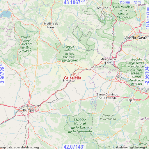
Grisaleña GPS coordinates[2]
42° 35' 28.392" North, 3° 15' 50.976" West
| Map corner | latitude | longitude |
|---|---|---|
| Upper-left | 43.10671°, | -3.96729° |
| Center: | 42.59122°, | -3.26416° |
| Lower-right: | 42.07143°, | -2.56104° |
| Map W x H: | 115.1×115.1 km | = 71.5×71.5mi |
| max Lat: | 43.74134° ⇑10.7% North |
| Grisaleña: | 42.59122° |
| min Lat: | ⇓89.3% South 27.64134° |
| min Long | Grisaleña | max Long |
| -18.00367° | -3.26416° | 4.2899° |
| W 50.9%⇐ | ⇒49.1% E |
Elevation
Elevation of Grisaleña is 743 m = 2438 ft, and this is 145 m = 476 ft above average elevation for this country.
| Max E: |
1682 m = 5518 ft | 40.3% |
| Grisaleña | 743 m 2438 ft | |
| Avg. | 598 m = 1962 ft | |
Min E: |
0 m = 0 ft | 59.7% |
See also: Spain elevation on elevation.city.
Geographical zone
Grisaleña is located in North temperate zone (between Tropic of Cancer and the Arctic Circle). Distance of this Northern Tropic circle is 2129.8 km =1323.4 mi to South.| Distance of | km | miles | from Grisaleña |
|---|---|---|---|
| North Pole | 5271.4 | 3275.5 | to North |
| Arctic Circle | 2665.5 | 1656.3 | to North |
| Tropic Cancer | 2129.8 | 1323.4 | to South |
| Equator | 4735.7 | 2942.6 | to South |


Nearby cities:
15 places around Grisaleña: (largest is in red/bold)
• Aguilar de Bureba
5.3 km =3.3 mi,  268°
268°
• Bañuelos de Bureba
9.9 km =6.2 mi,  187°
187°
• Berzosa de Bureba
4 km =2.5 mi,  357°
357°
• Briviesca
6.7 km =4.2 mi,  226°
226°
• Busto de Bureba
7.5 km =4.7 mi, 359°
• Cascajares de Bureba
10 km =6.2 mi,  12°
12°
• Cubo de Bureba
7.2 km =4.5 mi,  41°
41°
• Fuentebureba
5.3 km =3.3 mi,  26°
26°
• Miraveche
10.6 km =6.6 mi, 29°
• Quintanabureba
8.4 km =5.2 mi, 266°
• Quintanaélez
9.1 km =5.7 mi,  341°
341°
• Vallarta de Bureba
4.9 km =3 mi,  93°
93°
• Vileña
5.9 km =3.7 mi,  305°
305°
• Villanueva de Teba
10.5 km =6.5 mi,  52°
52°
• Zuñeda
3.5 km =2.2 mi,  63°
63°
Sources, notices
• [Note1] Compared only with cities in Spain existing in our database
• [Src1] Map data: © OpenStreetMap contributors (CC-BY-SA)
• [Src2] Other city data from geonames.org with taken over terms of usage.
• [Src3] Geographical zone / Annual Mean Temperature by Robert A. Rohde @ Wikipedia
