Zuera geodata
Zuera (Aragon) is a seat of a third-order administrative division; located in Spain in Europe/Madrid (GMT+2) time zone. With population of 6,098 people, there are 1124 cities with bigger population in this country. Compared to other cities in Spain, 70.2% of cities are located further ↓South; 79% of cities are located further ←West and 76.2% of cities have higher elevation than Zuera. Note1


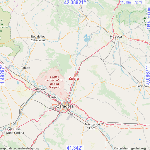
Zuera GPS coordinates[2]
41° 52' 3.9" North, 0° 47' 23.424" West
| Map corner | latitude | longitude |
|---|---|---|
| Upper-left | 42.38921°, | -1.49297° |
| Center: | 41.86775°, | -0.78984° |
| Lower-right: | 41.342°, | -0.08671° |
| Map W x H: | 116.4×116.4 km | = 72.3×72.3mi |
| max Lat: | 43.74134° ⇑29.8% North |
| Zuera: | 41.86775° |
| min Lat: | ⇓70.2% South 27.64134° |
| min Long | Zuera | max Long |
| -18.00367° | -0.78984° | 4.2899° |
| W 79%⇐ | ⇒21% E |
Elevation
Elevation of Zuera is 283 m = 928 ft, and this is 315 m = 1033 ft below average elevation for this country.
| Max E: |
1682 m = 5518 ft | 76.2% |
| Avg. | 598 m = 1962 ft | |
| Zuera | 283 m = 928 ft | |
Min E: |
0 m = 0 ft | 23.8% |
See also: Spain elevation on elevation.city.
Geographical zone
Zuera is located in North temperate zone (between Tropic of Cancer and the Arctic Circle). Distance of this Northern Tropic circle is 2049.3 km =1273.4 mi to South.| Distance of | km | miles | from Zuera |
|---|---|---|---|
| North Pole | 5351.8 | 3325.5 | to North |
| Arctic Circle | 2745.9 | 1706.2 | to North |
| Tropic Cancer | 2049.3 | 1273.4 | to South |
| Equator | 4655.3 | 2892.7 | to South |


Nearby cities:
15 places around Zuera: (largest is in red/bold)
• Alcalá de Gurrea
23.7 km =14.7 mi,  21°
21°
• Almozara
24.8 km =15.4 mi,  201°
201°
• Castejón de Valdejasa
21.1 km =13.1 mi,  306°
306°
• Gurrea de Gállego
16.6 km =10.3 mi,  8°
8°
• Leciñena
16.6 km =10.3 mi,  117°
117°
• Marracos
24.5 km =15.2 mi,  2°
2°
• Ontinar de Salz
8 km =5 mi, 19°
• Perdiguera
18.2 km =11.3 mi,  133°
133°
• San Mateo de Gállego
4.6 km =2.9 mi,  154°
154°
• Sierra de Luna
22.4 km =13.9 mi,  333°
333°
• Tardienta
24.2 km =15 mi,  59°
59°
• Torralba de Aragón
24.3 km =15.1 mi,  72°
72°
• Villamayor de Gállego
20.3 km =12.6 mi,  175°
175°
• Villanueva de Gállego
11.3 km =7 mi,  194°
194°
• Zaragoza
24.6 km =15.3 mi, 197°
Sources, notices
• [Note1] Compared only with cities in Spain existing in our database
• [Src1] Map data: © OpenStreetMap contributors (CC-BY-SA)
• [Src2] Other city data from geonames.org with taken over terms of usage.
• [Src3] Geographical zone / Annual Mean Temperature by Robert A. Rohde @ Wikipedia
