Almozara geodata
Almozara (Aragon) is a section of populated place; located in Spain in Europe/Madrid (GMT+2) time zone. With population of 25,767 people, there are 364 cities with bigger population in this country. Compared to other cities in Spain, 65% of cities are located further ↓South; 77.9% of cities are located further ←West and 80.9% of cities have higher elevation than Almozara. Note1


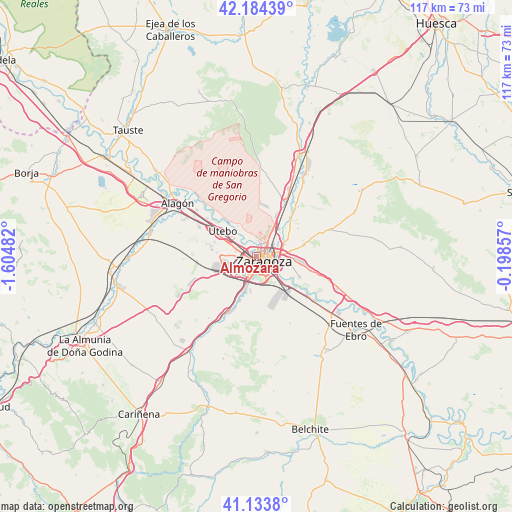
Almozara GPS coordinates[2]
41° 39' 40.464" North, 0° 54' 6.084" West
| Map corner | latitude | longitude |
|---|---|---|
| Upper-left | 42.18439°, | -1.60482° |
| Center: | 41.66124°, | -0.90169° |
| Lower-right: | 41.1338°, | -0.19857° |
| Map W x H: | 116.8×116.8 km | = 72.6×72.6mi |
| max Lat: | 43.74134° ⇑35% North |
| Almozara: | 41.66124° |
| min Lat: | ⇓65% South 27.64134° |
| min Long | Almozara | max Long |
| -18.00367° | -0.90169° | 4.2899° |
| W 77.9%⇐ | ⇒22.1% E |
Elevation
Elevation of Almozara is 205 m = 673 ft, and this is 393 m = 1289 ft below average elevation for this country.
| Max E: |
1682 m = 5518 ft | 80.9% |
| Avg. | 598 m = 1962 ft | |
| Almozara | 205 m = 673 ft | |
Min E: |
0 m = 0 ft | 19.1% |
See also: Spain elevation on elevation.city.
Geographical zone
Almozara is located in North temperate zone (between Tropic of Cancer and the Arctic Circle). Distance of this Northern Tropic circle is 2026.4 km =1259.1 mi to South.| Distance of | km | miles | from Almozara |
|---|---|---|---|
| North Pole | 5374.8 | 3339.7 | to North |
| Arctic Circle | 2768.9 | 1720.5 | to North |
| Tropic Cancer | 2026.4 | 1259.1 | to South |
| Equator | 4632.3 | 2878.4 | to South |


Nearby cities:
15 places around Almozara: (largest is in red/bold)
• Alfajarín
17.3 km =10.7 mi,  107°
107°
• Cadrete
12.7 km =7.9 mi,  202°
202°
• Cuarte de Huerva
7.8 km =4.8 mi, 199°
• Delicias
1.4 km =0.9 mi, 200°
• El Burgo de Ebro
16.6 km =10.3 mi,  126°
126°
• María de Huerva
15.7 km =9.8 mi,  209°
209°
• Montecanal
4.7 km =2.9 mi,  221°
221°
• Oliver-Valdefierro
3.2 km =2 mi,  234°
234°
• Puebla de Alfindén
12.9 km =8 mi,  104°
104°
• Sobradiel
14.2 km =8.8 mi,  307°
307°
• Torres de Berrellén
17.3 km =10.7 mi, 308°
• Utebo
9.6 km =6 mi,  302°
302°
• Villamayor de Gállego
11.1 km =6.9 mi,  75°
75°
• Villanueva de Gállego
13.6 km =8.5 mi,  28°
28°
• Zaragoza
2.1 km =1.3 mi, 105°
Sources, notices
• [Note1] Compared only with cities in Spain existing in our database
• [Src1] Map data: © OpenStreetMap contributors (CC-BY-SA)
• [Src2] Other city data from geonames.org with taken over terms of usage.
• [Src3] Geographical zone / Annual Mean Temperature by Robert A. Rohde @ Wikipedia
