Villanueva de Gállego geodata
Villanueva de Gállego (Aragon) is a seat of a third-order administrative division; located in Spain in Europe/Madrid (GMT+2) time zone. With population of 3,809 people, there are 1515 cities with bigger population in this country. Compared to other cities in Spain, 67.8% of cities are located further ↓South; 78.5% of cities are located further ←West and 78.2% of cities have higher elevation than Villanueva de Gállego. Note1
Administrative division(s):
- Level 1: Aragon
- Level 2: Provincia de Zaragoza
- Level 3: Villanueva de Gállego
Current local time in Villanueva de Gállego:
09:17 PM, ThursdayDifference from your time zone: hours


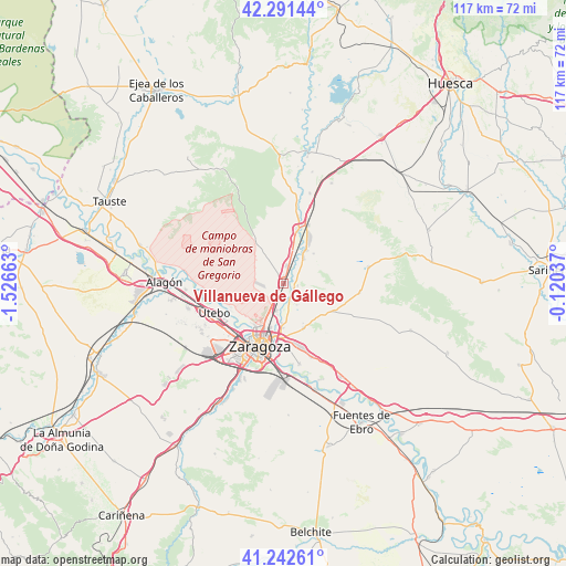
Villanueva de Gállego GPS coordinates[2]
41° 46' 9.012" North, 0° 49' 24.6" West
| Map corner | latitude | longitude |
|---|---|---|
| Upper-left | 42.29144°, | -1.52663° |
| Center: | 41.76917°, | -0.8235° |
| Lower-right: | 41.24261°, | -0.12037° |
| Map W x H: | 116.6×116.6 km | = 72.5×72.5mi |
| max Lat: | 43.74134° ⇑32.2% North |
| Villanueva de Gállego: | 41.76917° |
| min Lat: | ⇓67.8% South 27.64134° |
| min Long | Villanueva de G | max Long |
| -18.00367° | -0.8235° | 4.2899° |
| W 78.5%⇐ | ⇒21.5% E |
Elevation
Elevation of Villanueva de Gállego is 252 m = 827 ft, and this is 346 m = 1135 ft below average elevation for this country.
| Max E: |
1682 m = 5518 ft | 78.2% |
| Avg. | 598 m = 1962 ft | |
| Villanueva de Gállego | 252 m = 827 ft | |
Min E: |
0 m = 0 ft | 21.8% |
See also: Spain elevation on elevation.city.
Geographical zone
Villanueva de Gállego is located in North temperate zone (between Tropic of Cancer and the Arctic Circle). Distance of this Northern Tropic circle is 2038.4 km =1266.6 mi to South.| Distance of | km | miles | from Villanueva de Gállego |
|---|---|---|---|
| North Pole | 5362.8 | 3332.3 | to North |
| Arctic Circle | 2756.9 | 1713.1 | to North |
| Tropic Cancer | 2038.4 | 1266.6 | to South |
| Equator | 4644.3 | 2885.8 | to South |


Nearby cities:
15 places around Villanueva de Gállego: (largest is in red/bold)
• Alfajarín
19.9 km =12.4 mi,  150°
150°
• Almozara
13.6 km =8.5 mi,  208°
208°
• Delicias
15 km =9.3 mi, 207°
• Leciñena
17.9 km =11.1 mi,  79°
79°
• Montecanal
18.2 km =11.3 mi, 211°
• Oliver-Valdefierro
16.6 km =10.3 mi, 213°
• Ontinar de Salz
19.3 km =12 mi,  16°
16°
• Perdiguera
16 km =9.9 mi,  95°
95°
• Puebla de Alfindén
16.4 km =10.2 mi,  158°
158°
• San Mateo de Gállego
8.3 km =5.2 mi,  35°
35°
• Sobradiel
18.1 km =11.2 mi,  259°
259°
• Utebo
16.1 km =10 mi,  245°
245°
• Villamayor de Gállego
10.2 km =6.3 mi, 155°
• Zaragoza
13.3 km =8.3 mi,  199°
199°
• Zuera
11.3 km =7 mi,  14°
14°
Sources, notices
• [Note1] Compared only with cities in Spain existing in our database
• [Src1] Map data: © OpenStreetMap contributors (CC-BY-SA)
• [Src2] Other city data from geonames.org with taken over terms of usage.
• [Src3] Geographical zone / Annual Mean Temperature by Robert A. Rohde @ Wikipedia
