Leciñena geodata
Leciñena (Aragon) is a seat of a third-order administrative division; located in Spain in Europe/Madrid (GMT+2) time zone. With population of 1,267 people, there are 2670 cities with bigger population in this country. Compared to other cities in Spain, 68.5% of cities are located further ↓South; 80.5% of cities are located further ←West and 68% of cities have higher elevation than Leciñena. Note1


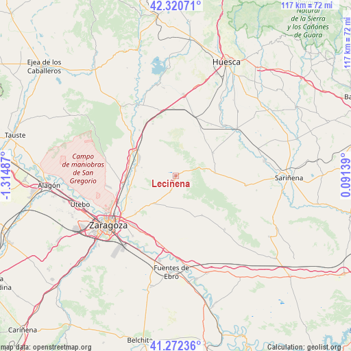
Leciñena GPS coordinates[2]
41° 47' 55.248" North, 0° 36' 42.264" West
| Map corner | latitude | longitude |
|---|---|---|
| Upper-left | 42.32071°, | -1.31487° |
| Center: | 41.79868°, | -0.61174° |
| Lower-right: | 41.27236°, | 0.09139° |
| Map W x H: | 116.6×116.6 km | = 72.5×72.5mi |
| max Lat: | 43.74134° ⇑31.5% North |
| Leciñena: | 41.79868° |
| min Lat: | ⇓68.5% South 27.64134° |
| min Long | Leciñena | max Long |
| -18.00367° | -0.61174° | 4.2899° |
| W 80.5%⇐ | ⇒19.5% E |
Elevation
Elevation of Leciñena is 417 m = 1368 ft, and this is 181 m = 594 ft below average elevation for this country.
| Max E: |
1682 m = 5518 ft | 68% |
| Avg. | 598 m = 1962 ft | |
| Leciñena | 417 m = 1368 ft | |
Min E: |
0 m = 0 ft | 32% |
See also: Spain elevation on elevation.city.
Geographical zone
Leciñena is located in North temperate zone (between Tropic of Cancer and the Arctic Circle). Distance of this Northern Tropic circle is 2041.7 km =1268.7 mi to South.| Distance of | km | miles | from Leciñena |
|---|---|---|---|
| North Pole | 5359.5 | 3330.2 | to North |
| Arctic Circle | 2753.6 | 1711 | to North |
| Tropic Cancer | 2041.7 | 1268.7 | to South |
| Equator | 4647.6 | 2887.9 | to South |


Nearby cities:
15 places around Leciñena: (largest is in red/bold)
• Alcubierre
13.2 km =8.2 mi,  85°
85°
• Alfajarín
21.9 km =13.6 mi,  200°
200°
• Farlete
15.7 km =9.8 mi,  146°
146°
• Ontinar de Salz
19.4 km =12.1 mi,  321°
321°
• Perdiguera
5.2 km =3.2 mi, 198°
• Puebla de Alfindén
21.9 km =13.6 mi,  212°
212°
• Robres
14.6 km =9.1 mi,  58°
58°
• San Mateo de Gállego
13.2 km =8.2 mi,  285°
285°
• Senés de Alcubierre
15.8 km =9.8 mi,  40°
40°
• Tardienta
20.8 km =12.9 mi,  17°
17°
• Torralba de Aragón
17.3 km =10.7 mi,  28°
28°
• Torres de Barbués
23.3 km =14.5 mi, 39°
• Villamayor de Gállego
18.3 km =11.4 mi,  226°
226°
• Villanueva de Gállego
17.9 km =11.1 mi,  259°
259°
• Zuera
16.6 km =10.3 mi,  297°
297°
Sources, notices
• [Note1] Compared only with cities in Spain existing in our database
• [Src1] Map data: © OpenStreetMap contributors (CC-BY-SA)
• [Src2] Other city data from geonames.org with taken over terms of usage.
• [Src3] Geographical zone / Annual Mean Temperature by Robert A. Rohde @ Wikipedia
