Yeles geodata
Yeles (Castille-La Mancha) is a seat of a third-order administrative division; located in Spain in Europe/Madrid (GMT+2) time zone. With population of 2,967 people, there are 1732 cities with bigger population in this country. Compared to other cities in Spain, 68.4% of cities are located further ↑North; 56.8% of cities are located further →East and 58.2% of cities have higher elevation than Yeles. Note1


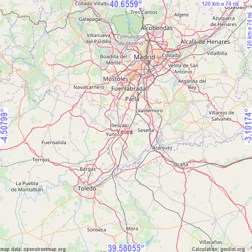
Yeles GPS coordinates[2]
40° 7' 13.26" North, 3° 48' 17.532" West
| Map corner | latitude | longitude |
|---|---|---|
| Upper-left | 40.6559°, | -4.50799° |
| Center: | 40.12035°, | -3.80487° |
| Lower-right: | 39.58055°, | -3.10174° |
| Map W x H: | 119.6×119.6 km | = 74.3×74.3mi |
| max Lat: | 43.74134° ⇑68.4% North |
| Yeles: | 40.12035° |
| min Lat: | ⇓31.6% South 27.64134° |
| min Long | Yeles | max Long |
| -18.00367° | -3.80487° | 4.2899° |
| W 43.2%⇐ | ⇒56.8% E |
Elevation
Elevation of Yeles is 550 m = 1804 ft, and this is 48 m = 157 ft below average elevation for this country.
| Max E: |
1682 m = 5518 ft | 58.2% |
| Avg. | 598 m = 1962 ft | |
| Yeles | 550 m = 1804 ft | |
Min E: |
0 m = 0 ft | 41.8% |
See also: Spain elevation on elevation.city.
Geographical zone
Yeles is located in North temperate zone (between Tropic of Cancer and the Arctic Circle). Distance of this Northern Tropic circle is 1855 km =1152.6 mi to South.| Distance of | km | miles | from Yeles |
|---|---|---|---|
| North Pole | 5546.1 | 3446.2 | to North |
| Arctic Circle | 2940.2 | 1827 | to North |
| Tropic Cancer | 1855 | 1152.6 | to South |
| Equator | 4461 | 2771.9 | to South |


Nearby cities:
15 places around Yeles: (largest is in red/bold)
• Borox
8.1 km =5 mi,  135°
135°
• Carranque
9.8 km =6.1 mi,  303°
303°
• Casarrubuelos
6.1 km =3.8 mi,  338°
338°
• Cedillo del Condado
9.9 km =6.2 mi,  265°
265°
• Cubas
8.1 km =5 mi, 341°
• El Viso de San Juan
9.9 km =6.2 mi,  283°
283°
• Esquivias
3.7 km =2.3 mi,  118°
118°
• Illescas
3.6 km =2.2 mi, 273°
• Numancia de la Sagra
6.5 km =4 mi,  217°
217°
• Pantoja
8.9 km =5.5 mi,  195°
195°
• Seseña
9.3 km =5.8 mi,  100°
100°
• Torrejón de Velasco
7.8 km =4.8 mi,  17°
17°
• Torrejón de la Calzada
8.8 km =5.5 mi,  4°
4°
• Ugena
7.2 km =4.5 mi, 303°
• Yuncos
6.8 km =4.2 mi,  235°
235°
Sources, notices
• [Note1] Compared only with cities in Spain existing in our database
• [Src1] Map data: © OpenStreetMap contributors (CC-BY-SA)
• [Src2] Other city data from geonames.org with taken over terms of usage.
• [Src3] Geographical zone / Annual Mean Temperature by Robert A. Rohde @ Wikipedia
