Seseña geodata
Seseña (Castille-La Mancha) is a seat of a third-order administrative division; located in Spain in Europe/Madrid (GMT+2) time zone. With population of 16,231 people, there are 583 cities with bigger population in this country. Compared to other cities in Spain, 68.7% of cities are located further ↑North; 55.3% of cities are located further →East and 54.1% of cities have higher elevation than Seseña. Note1


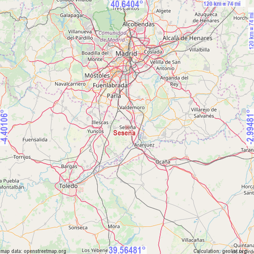
Seseña GPS coordinates[2]
40° 6' 17.028" North, 3° 41' 52.548" West
| Map corner | latitude | longitude |
|---|---|---|
| Upper-left | 40.6404°, | -4.40106° |
| Center: | 40.10473°, | -3.69793° |
| Lower-right: | 39.56481°, | -2.99481° |
| Map W x H: | 119.6×119.6 km | = 74.3×74.3mi |
| max Lat: | 43.74134° ⇑68.7% North |
| Seseña: | 40.10473° |
| min Lat: | ⇓31.3% South 27.64134° |
| min Long | Seseña | max Long |
| -18.00367° | -3.69793° | 4.2899° |
| W 44.7%⇐ | ⇒55.3% E |
Elevation
Elevation of Seseña is 610 m = 2001 ft, and this is 12 m = 39 ft above average elevation for this country.
| Max E: |
1682 m = 5518 ft | 54.1% |
| Seseña | 610 m 2001 ft | |
| Avg. | 598 m = 1962 ft | |
Min E: |
0 m = 0 ft | 45.9% |
See also: Spain elevation on elevation.city.
Geographical zone
Seseña is located in North temperate zone (between Tropic of Cancer and the Arctic Circle). Distance of this Northern Tropic circle is 1853.3 km =1151.6 mi to South.| Distance of | km | miles | from Seseña |
|---|---|---|---|
| North Pole | 5547.8 | 3447.2 | to North |
| Arctic Circle | 2941.9 | 1828 | to North |
| Tropic Cancer | 1853.3 | 1151.6 | to South |
| Equator | 4459.2 | 2770.8 | to South |


Nearby cities:
15 places around Seseña: (largest is in red/bold)
• Aranjuez
11.5 km =7.1 mi,  135°
135°
• Añover de Tajo
14.1 km =8.8 mi,  204°
204°
• Borox
5.3 km =3.3 mi,  219°
219°
• Casarrubuelos
13.5 km =8.4 mi,  303°
303°
• Ciempozuelos
8.9 km =5.5 mi,  47°
47°
• Esquivias
5.9 km =3.7 mi,  269°
269°
• Illescas
12.8 km =8 mi,  278°
278°
• La Alameda de la Sagra
13.1 km =8.1 mi, 217°
• Numancia de la Sagra
13.5 km =8.4 mi,  255°
255°
• Pantoja
13.4 km =8.3 mi,  239°
239°
• Titulcia
11.6 km =7.2 mi,  72°
72°
• Torrejón de Velasco
11.4 km =7.1 mi,  323°
323°
• Torrejón de la Calzada
13.4 km =8.3 mi, 321°
• Valdemoro
9.7 km =6 mi,  9°
9°
• Yeles
9.3 km =5.8 mi, 280°
Sources, notices
• [Note1] Compared only with cities in Spain existing in our database
• [Src1] Map data: © OpenStreetMap contributors (CC-BY-SA)
• [Src2] Other city data from geonames.org with taken over terms of usage.
• [Src3] Geographical zone / Annual Mean Temperature by Robert A. Rohde @ Wikipedia
