Carranque geodata
Carranque (Castille-La Mancha) is a seat of a third-order administrative division; located in Spain in Europe/Madrid (GMT+2) time zone. With population of 2,494 people, there are 1905 cities with bigger population in this country. Compared to other cities in Spain, 67.7% of cities are located further ↑North; 58.2% of cities are located further →East and 50.3% of cities have lower elevation than Carranque. Note1
Administrative division(s):
- Level 1: Castille-La Mancha
- Level 2: Province of Toledo
- Level 3: Carranque


Carranque GPS coordinates[2]
40° 10' 11.136" North, 3° 54' 3.312" West
| Map corner | latitude | longitude |
|---|---|---|
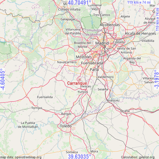
| Upper-left | 40.70491°, | -4.60405° |
| Center: | 40.16976°, | -3.90092° |
| Lower-right: | 39.63035°, | -3.1978° |
| Map W x H: | 119.5×119.5 km | = 74.3×74.3mi |
| max Lat: | 43.74134° ⇑67.7% North |
| Carranque: | 40.16976° |
| min Lat: | ⇓32.3% South 27.64134° |
| min Long | Carranque | max Long |
| -18.00367° | -3.90092° | 4.2899° |
| W 41.8%⇐ | ⇒58.2% E |
Elevation
Elevation of Carranque is 662 m = 2172 ft, and this is 64 m = 210 ft above average elevation for this country.
| Max E: |
1682 m = 5518 ft | 49.7% |
| Carranque | 662 m 2172 ft | |
| Avg. | 598 m = 1962 ft | |
Min E: |
0 m = 0 ft | 50.3% |
See also: Spain elevation on elevation.city.
Geographical zone
Carranque is located in North temperate zone (between Tropic of Cancer and the Arctic Circle). Distance of this Northern Tropic circle is 1860.5 km =1156.1 mi to South.| Distance of | km | miles | from Carranque |
|---|---|---|---|
| North Pole | 5540.6 | 3442.8 | to North |
| Arctic Circle | 2934.7 | 1823.5 | to North |
| Tropic Cancer | 1860.5 | 1156.1 | to South |
| Equator | 4466.5 | 2775.4 | to South |


Nearby cities:
15 places around Carranque: (largest is in red/bold)
• Batres
4.8 km =3 mi,  336°
336°
• Casarrubuelos
5.9 km =3.7 mi,  88°
88°
• Cedillo del Condado
6.6 km =4.1 mi,  195°
195°
• Cubas
6 km =3.7 mi,  69°
69°
• El Viso de San Juan
3.5 km =2.2 mi,  205°
205°
• El Álamo
10.4 km =6.5 mi,  310°
310°
• Griñón
6.2 km =3.9 mi,  39°
39°
• Illescas
7 km =4.3 mi,  139°
139°
• Lominchar
10.4 km =6.5 mi, 212°
• Palomeque
7.7 km =4.8 mi,  223°
223°
• Serranillos del Valle
3.9 km =2.4 mi,  24°
24°
• Torrejón de la Calzada
9.4 km =5.8 mi, 69°
• Ugena
2.6 km =1.6 mi,  126°
126°
• Yeles
9.8 km =6.1 mi,  123°
123°
• Yuncos
9.7 km =6 mi,  164°
164°
Sources, notices
• [Note1] Compared only with cities in Spain existing in our database
• [Src1] Map data: © OpenStreetMap contributors (CC-BY-SA)
• [Src2] Other city data from geonames.org with taken over terms of usage.
• [Src3] Geographical zone / Annual Mean Temperature by Robert A. Rohde @ Wikipedia
