Pantoja geodata
Pantoja (Castille-La Mancha) is a seat of a third-order administrative division; located in Spain in Europe/Madrid (GMT+1) time zone. With population of 3,071 people, there are 1698 cities with bigger population in this country. Compared to other cities in Spain, 69.7% of cities are located further ↑North; 57.3% of cities are located further →East and 60.2% of cities have higher elevation than Pantoja. Note1
Administrative division(s):
- Level 1: Castille-La Mancha
- Level 2: Province of Toledo
- Level 3: Pantoja


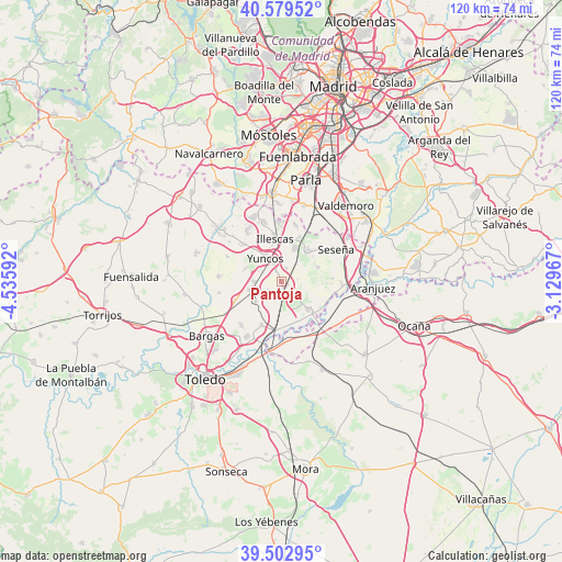
Pantoja GPS coordinates[2]
40° 2' 36.096" North, 3° 49' 58.08" West
| Map corner | latitude | longitude |
|---|---|---|
| Upper-left | 40.57952°, | -4.53592° |
| Center: | 40.04336°, | -3.8328° |
| Lower-right: | 39.50295°, | -3.12967° |
| Map W x H: | 119.7×119.7 km | = 74.4×74.4mi |
| max Lat: | 43.74134° ⇑69.7% North |
| Pantoja: | 40.04336° |
| min Lat: | ⇓30.3% South 27.64134° |
| min Long | Pantoja | max Long |
| -18.00367° | -3.8328° | 4.2899° |
| W 42.7%⇐ | ⇒57.3% E |
Elevation
Elevation of Pantoja is 524 m = 1719 ft, and this is 74 m = 243 ft below average elevation for this country.
| Max E: |
1682 m = 5518 ft | 60.2% |
| Avg. | 598 m = 1962 ft | |
| Pantoja | 524 m = 1719 ft | |
Min E: |
0 m = 0 ft | 39.8% |
See also: Spain elevation on elevation.city.
Geographical zone
Pantoja is located in North temperate zone (between Tropic of Cancer and the Arctic Circle). Distance of this Northern Tropic circle is 1846.5 km =1147.4 mi to South.| Distance of | km | miles | from Pantoja |
|---|---|---|---|
| North Pole | 5554.7 | 3451.5 | to North |
| Arctic Circle | 2948.8 | 1832.3 | to North |
| Tropic Cancer | 1846.5 | 1147.4 | to South |
| Equator | 4452.4 | 2766.6 | to South |


Nearby cities:
15 places around Pantoja: (largest is in red/bold)
• Añover de Tajo
8.3 km =5.2 mi,  136°
136°
• Borox
8.5 km =5.3 mi,  71°
71°
• Cabañas de la Sagra
10.5 km =6.5 mi,  246°
246°
• Cedillo del Condado
10.8 km =6.7 mi,  315°
315°
• Cobeja
3.2 km =2 mi,  218°
218°
• Esquivias
8.8 km =5.5 mi,  39°
39°
• Illescas
8.8 km =5.5 mi,  352°
352°
• La Alameda de la Sagra
4.9 km =3 mi, 135°
• Lominchar
12.6 km =7.8 mi,  294°
294°
• Magán
12.4 km =7.7 mi, 222°
• Numancia de la Sagra
3.7 km =2.3 mi,  335°
335°
• Villaseca de la Sagra
10 km =6.2 mi,  205°
205°
• Yeles
8.9 km =5.5 mi,  15°
15°
• Yuncler
5.7 km =3.5 mi,  267°
267°
• Yuncos
5.7 km =3.5 mi,  325°
325°
Sources, notices
• [Note1] Compared only with cities in Spain existing in our database
• [Src1] Map data: © OpenStreetMap contributors (CC-BY-SA)
• [Src2] Other city data from geonames.org with taken over terms of usage.
• [Src3] Geographical zone / Annual Mean Temperature by Robert A. Rohde @ Wikipedia
