Cedillo del Condado geodata
Cedillo del Condado (Castille-La Mancha) is a seat of a third-order administrative division; located in Spain in Europe/Madrid (GMT+2) time zone. With population of 2,070 people, there are 2119 cities with bigger population in this country. Compared to other cities in Spain, 68.6% of cities are located further ↑North; 58.5% of cities are located further →East and 51.6% of cities have higher elevation than Cedillo del Condado. Note1
Administrative division(s):
- Level 1: Castille-La Mancha
- Level 2: Province of Toledo
- Level 3: Cedillo del Condado


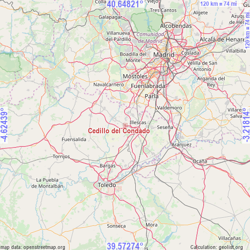
Cedillo del Condado GPS coordinates[2]
40° 6' 45.36" North, 3° 55' 16.572" West
| Map corner | latitude | longitude |
|---|---|---|
| Upper-left | 40.64821°, | -4.62439° |
| Center: | 40.1126°, | -3.92127° |
| Lower-right: | 39.57274°, | -3.21814° |
| Map W x H: | 119.6×119.6 km | = 74.3×74.3mi |
| max Lat: | 43.74134° ⇑68.6% North |
| Cedillo del Condado: | 40.1126° |
| min Lat: | ⇓31.4% South 27.64134° |
| min Long | Cedillo del Con | max Long |
| -18.00367° | -3.92127° | 4.2899° |
| W 41.5%⇐ | ⇒58.5% E |
Elevation
Elevation of Cedillo del Condado is 642 m = 2106 ft, and this is 44 m = 144 ft above average elevation for this country.
| Max E: |
1682 m = 5518 ft | 51.6% |
| Cedillo del Condado | 642 m 2106 ft | |
| Avg. | 598 m = 1962 ft | |
Min E: |
0 m = 0 ft | 48.4% |
See also: Spain elevation on elevation.city.
Geographical zone
Cedillo del Condado is located in North temperate zone (between Tropic of Cancer and the Arctic Circle). Distance of this Northern Tropic circle is 1854.2 km =1152.1 mi to South.| Distance of | km | miles | from Cedillo del Condado |
|---|---|---|---|
| North Pole | 5547 | 3446.7 | to North |
| Arctic Circle | 2941.1 | 1827.5 | to North |
| Tropic Cancer | 1854.2 | 1152.1 | to South |
| Equator | 4460.1 | 2771.4 | to South |


Nearby cities:
15 places around Cedillo del Condado: (largest is in red/bold)
• Carranque
6.6 km =4.1 mi,  15°
15°
• Casarrubuelos
10.1 km =6.3 mi,  49°
49°
• Chozas de Canales
10.5 km =6.5 mi,  262°
262°
• El Viso de San Juan
3.2 km =2 mi,  4°
4°
• Illescas
6.4 km =4 mi,  80°
80°
• Lominchar
4.6 km =2.9 mi,  237°
237°
• Numancia de la Sagra
7.3 km =4.5 mi,  125°
125°
• Palomeque
3.7 km =2.3 mi,  282°
282°
• Pantoja
10.8 km =6.7 mi,  135°
135°
• Recas
8.9 km =5.5 mi,  221°
221°
• Serranillos del Valle
10.5 km =6.5 mi, 18°
• Ugena
6.1 km =3.8 mi,  38°
38°
• Yeles
9.9 km =6.2 mi,  85°
85°
• Yuncler
8.2 km =5.1 mi,  167°
167°
• Yuncos
5.2 km =3.2 mi,  124°
124°
Sources, notices
• [Note1] Compared only with cities in Spain existing in our database
• [Src1] Map data: © OpenStreetMap contributors (CC-BY-SA)
• [Src2] Other city data from geonames.org with taken over terms of usage.
• [Src3] Geographical zone / Annual Mean Temperature by Robert A. Rohde @ Wikipedia
