Wamba geodata
Wamba (Castille and León) is a seat of a third-order administrative division; located in Spain in Europe/Madrid (GMT+2) time zone. With population of 372 people, there are 4232 cities with bigger population in this country. Compared to other cities in Spain, 65.4% of cities are located further ↓South; 71.4% of cities are located further →East and 66.6% of cities have lower elevation than Wamba. Note1
Administrative division(s):
- Level 1: Castille and León
- Level 2: Provincia de Valladolid
- Level 3: Wamba


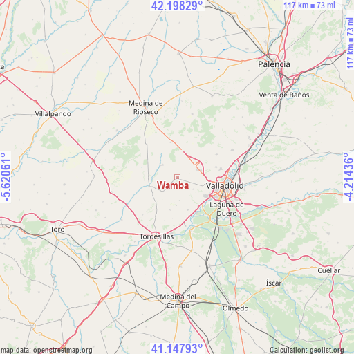
Wamba GPS coordinates[2]
41° 40' 30.9" North, 4° 55' 2.928" West
| Map corner | latitude | longitude |
|---|---|---|
| Upper-left | 42.19829°, | -5.62061° |
| Center: | 41.67525°, | -4.91748° |
| Lower-right: | 41.14793°, | -4.21436° |
| Map W x H: | 116.8×116.8 km | = 72.6×72.6mi |
| max Lat: | 43.74134° ⇑34.6% North |
| Wamba: | 41.67525° |
| min Lat: | ⇓65.4% South 27.64134° |
| min Long | Wamba | max Long |
| -18.00367° | -4.91748° | 4.2899° |
| W 28.6%⇐ | ⇒71.4% E |
Elevation
Elevation of Wamba is 789 m = 2589 ft, and this is 191 m = 627 ft above average elevation for this country.
| Max E: |
1682 m = 5518 ft | 33.4% |
| Wamba | 789 m 2589 ft | |
| Avg. | 598 m = 1962 ft | |
Min E: |
0 m = 0 ft | 66.6% |
See also: Spain elevation on elevation.city.
Geographical zone
Wamba is located in North temperate zone (between Tropic of Cancer and the Arctic Circle). Distance of this Northern Tropic circle is 2027.9 km =1260.1 mi to South.| Distance of | km | miles | from Wamba |
|---|---|---|---|
| North Pole | 5373.2 | 3338.8 | to North |
| Arctic Circle | 2767.3 | 1719.5 | to North |
| Tropic Cancer | 2027.9 | 1260.1 | to South |
| Equator | 4633.9 | 2879.4 | to South |


Nearby cities:
15 places around Wamba: (largest is in red/bold)
• Arroyo de la Encomienda
12.4 km =7.7 mi,  126°
126°
• Castrodeza
4.5 km =2.8 mi,  229°
229°
• Ciguñuela
6.3 km =3.9 mi, 127°
• Geria
11.3 km =7 mi,  162°
162°
• Peñaflor de Hornija
6.8 km =4.2 mi,  306°
306°
• Robladillo
7.5 km =4.7 mi,  175°
175°
• San Pelayo
9.7 km =6 mi,  273°
273°
• Simancas
12 km =7.5 mi,  141°
141°
• Torrecilla de la Torre
11 km =6.8 mi, 265°
• Torrelobatón
9.4 km =5.8 mi,  252°
252°
• Velliza
11 km =6.8 mi,  192°
192°
• Villanubla
6.8 km =4.2 mi,  67°
67°
• Villasexmir
12.9 km =8 mi, 251°
• Villán de Tordesillas
9.1 km =5.7 mi, 182°
• Zaratán
11.2 km =7 mi,  98°
98°
Sources, notices
• [Note1] Compared only with cities in Spain existing in our database
• [Src1] Map data: © OpenStreetMap contributors (CC-BY-SA)
• [Src2] Other city data from geonames.org with taken over terms of usage.
• [Src3] Geographical zone / Annual Mean Temperature by Robert A. Rohde @ Wikipedia
