Simancas geodata
Simancas (Castille and León) is a seat of a third-order administrative division; located in Spain in Europe/Madrid (GMT+2) time zone. With population of 4,611 people, there are 1368 cities with bigger population in this country. Compared to other cities in Spain, 63.2% of cities are located further ↓South; 70% of cities are located further →East and 56.6% of cities have lower elevation than Simancas. Note1
Administrative division(s):
- Level 1: Castille and León
- Level 2: Provincia de Valladolid
- Level 3: Simancas


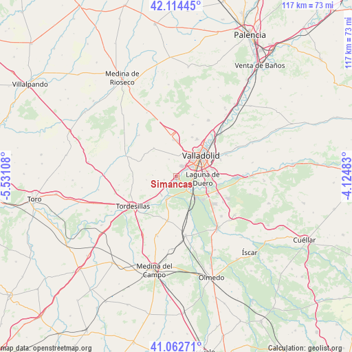
Simancas GPS coordinates[2]
41° 35' 26.592" North, 4° 49' 40.656" West
| Map corner | latitude | longitude |
|---|---|---|
| Upper-left | 42.11445°, | -5.53108° |
| Center: | 41.59072°, | -4.82796° |
| Lower-right: | 41.06271°, | -4.12483° |
| Map W x H: | 116.9×116.9 km | = 72.6×72.6mi |
| max Lat: | 43.74134° ⇑36.8% North |
| Simancas: | 41.59072° |
| min Lat: | ⇓63.2% South 27.64134° |
| min Long | Simancas | max Long |
| -18.00367° | -4.82796° | 4.2899° |
| W 30%⇐ | ⇒70% E |
Elevation
Elevation of Simancas is 720 m = 2362 ft, and this is 122 m = 400 ft above average elevation for this country.
| Max E: |
1682 m = 5518 ft | 43.4% |
| Simancas | 720 m 2362 ft | |
| Avg. | 598 m = 1962 ft | |
Min E: |
0 m = 0 ft | 56.6% |
See also: Spain elevation on elevation.city.
Geographical zone
Simancas is located in North temperate zone (between Tropic of Cancer and the Arctic Circle). Distance of this Northern Tropic circle is 2018.5 km =1254.2 mi to South.| Distance of | km | miles | from Simancas |
|---|---|---|---|
| North Pole | 5382.6 | 3344.6 | to North |
| Arctic Circle | 2776.7 | 1725.4 | to North |
| Tropic Cancer | 2018.5 | 1254.2 | to South |
| Equator | 4624.5 | 2873.5 | to South |


Nearby cities:
15 places around Simancas: (largest is in red/bold)
• Arroyo de la Encomienda
3.3 km =2.1 mi,  50°
50°
• Boecillo
12 km =7.5 mi,  117°
117°
• Ciguñuela
6 km =3.7 mi,  336°
336°
• Cistérniga
12 km =7.5 mi,  78°
78°
• Geria
4.3 km =2.7 mi,  251°
251°
• Laguna de Duero
8.8 km =5.5 mi,  96°
96°
• Robladillo
7.1 km =4.4 mi,  286°
286°
• San Miguel del Pino
11.4 km =7.1 mi,  217°
217°
• Valladolid
11.2 km =7 mi, 50°
• Velliza
9.9 km =6.2 mi,  262°
262°
• Viana de Cega
9.3 km =5.8 mi,  137°
137°
• Villanueva de Duero
8.6 km =5.3 mi,  202°
202°
• Villán de Tordesillas
7.8 km =4.8 mi,  271°
271°
• Wamba
12 km =7.5 mi,  321°
321°
• Zaratán
8.5 km =5.3 mi,  25°
25°
Sources, notices
• [Note1] Compared only with cities in Spain existing in our database
• [Src1] Map data: © OpenStreetMap contributors (CC-BY-SA)
• [Src2] Other city data from geonames.org with taken over terms of usage.
• [Src3] Geographical zone / Annual Mean Temperature by Robert A. Rohde @ Wikipedia
