Gasteiz / Vitoria geodata
Gasteiz / Vitoria (Basque Country) is a seat of a first-order administrative division; located in Spain in Europe/Madrid (GMT+2) time zone. With population of 235,661 people, there are 22 cities with bigger population in this country. Compared to other cities in Spain, 93.1% of cities are located further ↓South; 58.9% of cities are located further ←West and 58.5% of cities have higher elevation than Gasteiz / Vitoria. Note1
Administrative division(s):
- Level 1: Basque Country
- Level 2: Araba / Álava
- Level 3: Gasteiz / Vitoria


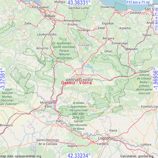
Gasteiz / Vitoria GPS coordinates[2]
42° 50' 59.928" North, 2° 40' 21.648" West
| Map corner | latitude | longitude |
|---|---|---|
| Upper-left | 43.36331°, | -3.37581° |
| Center: | 42.84998°, | -2.67268° |
| Lower-right: | 42.33234°, | -1.96956° |
| Map W x H: | 114.6×114.6 km | = 71.2×71.2mi |
| max Lat: | 43.74134° ⇑6.9% North |
| Gasteiz / Vitoria: | 42.84998° |
| min Lat: | ⇓93.1% South 27.64134° |
| min Long | Gasteiz / Vitor | max Long |
| -18.00367° | -2.67268° | 4.2899° |
| W 58.9%⇐ | ⇒41.1% E |
Elevation
Elevation of Gasteiz / Vitoria is 547 m = 1795 ft, and this is 51 m = 167 ft below average elevation for this country.
| Max E: |
1682 m = 5518 ft | 58.5% |
| Avg. | 598 m = 1962 ft | |
| Gasteiz / Vitoria | 547 m = 1795 ft | |
Min E: |
0 m = 0 ft | 41.5% |
See also: Gasteiz / Vitoria elevation on elevation.city.
Geographical zone
Gasteiz / Vitoria is located in North temperate zone (between Tropic of Cancer and the Arctic Circle). Distance of this Northern Tropic circle is 2158.6 km =1341.3 mi to South.| Distance of | km | miles | from Gasteiz / Vitoria |
|---|---|---|---|
| North Pole | 5242.6 | 3257.6 | to North |
| Arctic Circle | 2636.7 | 1638.4 | to North |
| Tropic Cancer | 2158.6 | 1341.3 | to South |
| Equator | 4764.5 | 2960.5 | to South |


Nearby cities:
15 places around Gasteiz / Vitoria: (largest is in red/bold)
• Agurain / Salvatierra
22.9 km =14.2 mi,  89°
89°
• Aretxabaleta
24.6 km =15.3 mi,  33°
33°
• Armiñón
21.5 km =13.4 mi,  229°
229°
• Arrasate / Mondragón
28.1 km =17.5 mi, 31°
• Berantevilla
24 km =14.9 mi,  219°
219°
• Bernedo
28.6 km =17.8 mi,  150°
150°
• Berrostegieta
5.1 km =3.2 mi, 216°
• Eskoriatza
22.2 km =13.8 mi, 32°
• Lagrán
25.9 km =16.1 mi,  163°
163°
• Leintz-Gatzaga
17.4 km =10.8 mi, 29°
• Murgia
16.9 km =10.5 mi,  314°
314°
• Otxandio
20.5 km =12.7 mi,  5°
5°
• Ubide
19.4 km =12.1 mi,  356°
356°
• Zambrana
26.9 km =16.7 mi, 218°
• Zeanuri
28.5 km =17.7 mi,  347°
347°
In other languages:
- In Spanish: Vitoria
- In France: Vitoria
- In German: Vitoria
- In Italian: Vitoria
- In Russian: Витория-Гастейс
Sources, notices
• [Note1] Compared only with cities in Spain existing in our database
• [Src1] Map data: © OpenStreetMap contributors (CC-BY-SA)
• [Src2] Other city data from geonames.org with taken over terms of usage.
• [Src3] Geographical zone / Annual Mean Temperature by Robert A. Rohde @ Wikipedia
