Berrostegieta geodata
Berrostegieta (Basque Country) is a populated place; located in Spain in Europe/Madrid (GMT+2) time zone. With population of 590 people, there are 3637 cities with bigger population in this country. Compared to other cities in Spain, 92.8% of cities are located further ↓South; 58.5% of cities are located further ←West and 53.4% of cities have higher elevation than Berrostegieta. Note1
Administrative division(s):
- Level 1: Basque Country
- Level 2: Araba / Álava
- Level 3: Gasteiz / Vitoria


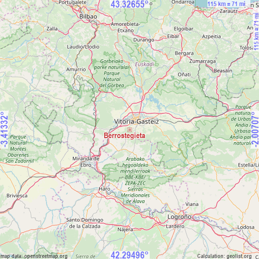
Berrostegieta GPS coordinates[2]
42° 48' 46.476" North, 2° 42' 36.684" West
| Map corner | latitude | longitude |
|---|---|---|
| Upper-left | 43.32655°, | -3.41332° |
| Center: | 42.81291°, | -2.71019° |
| Lower-right: | 42.29496°, | -2.00707° |
| Map W x H: | 114.7×114.7 km | = 71.3×71.3mi |
| max Lat: | 43.74134° ⇑7.2% North |
| Berrostegieta: | 42.81291° |
| min Lat: | ⇓92.8% South 27.64134° |
| min Long | Berrostegieta | max Long |
| -18.00367° | -2.71019° | 4.2899° |
| W 58.5%⇐ | ⇒41.5% E |
Elevation
Elevation of Berrostegieta is 619 m = 2031 ft, and this is 21 m = 69 ft above average elevation for this country.
| Max E: |
1682 m = 5518 ft | 53.4% |
| Berrostegieta | 619 m 2031 ft | |
| Avg. | 598 m = 1962 ft | |
Min E: |
0 m = 0 ft | 46.6% |
See also: Spain elevation on elevation.city.
Geographical zone
Berrostegieta is located in North temperate zone (between Tropic of Cancer and the Arctic Circle). Distance of this Northern Tropic circle is 2154.4 km =1338.7 mi to South.| Distance of | km | miles | from Berrostegieta |
|---|---|---|---|
| North Pole | 5246.7 | 3260.1 | to North |
| Arctic Circle | 2640.8 | 1640.9 | to North |
| Tropic Cancer | 2154.4 | 1338.7 | to South |
| Equator | 4760.3 | 2957.9 | to South |


Nearby cities:
15 places around Berrostegieta: (largest is in red/bold)
• Agurain / Salvatierra
26.4 km =16.4 mi,  80°
80°
• Armiñón
16.5 km =10.3 mi,  232°
232°
• Bastida / Labastida
25.8 km =16 mi,  195°
195°
• Berantevilla
18.9 km =11.7 mi,  219°
219°
• Briñas
25.6 km =15.9 mi, 202°
• Gasteiz / Vitoria
5.1 km =3.2 mi,  36°
36°
• Lagrán
23.2 km =14.4 mi,  153°
153°
• Leintz-Gatzaga
22.5 km =14 mi,  30°
30°
• Miranda de Ebro
23.9 km =14.9 mi, 233°
• Murgia
18.3 km =11.4 mi,  330°
330°
• Otxandio
25 km =15.5 mi,  11°
11°
• Ubide
23.5 km =14.6 mi,  4°
4°
• Villalba de Rioja
26.8 km =16.7 mi,  212°
212°
• Zambrana
21.8 km =13.5 mi, 219°
• Ábalos
26.8 km =16.7 mi,  179°
179°
Sources, notices
• [Note1] Compared only with cities in Spain existing in our database
• [Src1] Map data: © OpenStreetMap contributors (CC-BY-SA)
• [Src2] Other city data from geonames.org with taken over terms of usage.
• [Src3] Geographical zone / Annual Mean Temperature by Robert A. Rohde @ Wikipedia
