Arrasate / Mondragón geodata
Arrasate / Mondragón (Basque Country) is a populated place; located in Spain in Europe/Madrid (GMT+2) time zone. With population of 22,064 people, there are 422 cities with bigger population in this country. Compared to other cities in Spain, 95% of cities are located further ↓South; 61.1% of cities are located further ←West and 80.5% of cities have higher elevation than Arrasate / Mondragón. Note1


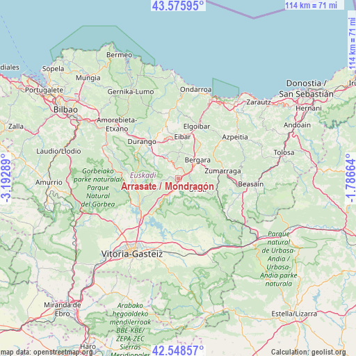
Arrasate / Mondragón GPS coordinates[2]
43° 3' 51.876" North, 2° 29' 23.172" West
| Map corner | latitude | longitude |
|---|---|---|
| Upper-left | 43.57595°, | -3.19289° |
| Center: | 43.06441°, | -2.48977° |
| Lower-right: | 42.54857°, | -1.78664° |
| Map W x H: | 114.2×114.2 km | = 71×71mi |
| max Lat: | 43.74134° ⇑5% North |
| Arrasate / Mondragón: | 43.06441° |
| min Lat: | ⇓95% South 27.64134° |
| min Long | Arrasate / Mond | max Long |
| -18.00367° | -2.48977° | 4.2899° |
| W 61.1%⇐ | ⇒38.9% E |
Elevation
Elevation of Arrasate / Mondragón is 211 m = 692 ft, and this is 387 m = 1270 ft below average elevation for this country.
| Max E: |
1682 m = 5518 ft | 80.5% |
| Avg. | 598 m = 1962 ft | |
| Arrasate / Mondragón | 211 m = 692 ft | |
Min E: |
0 m = 0 ft | 19.5% |
See also: Spain elevation on elevation.city.
Geographical zone
Arrasate / Mondragón is located in North temperate zone (between Tropic of Cancer and the Arctic Circle). Distance of this Northern Tropic circle is 2182.4 km =1356.1 mi to South.| Distance of | km | miles | from Arrasate / Mondragón |
|---|---|---|---|
| North Pole | 5218.7 | 3242.7 | to North |
| Arctic Circle | 2612.9 | 1623.6 | to North |
| Tropic Cancer | 2182.4 | 1356.1 | to South |
| Equator | 4788.3 | 2975.3 | to South |


Nearby cities:
15 places around Arrasate / Mondragón: (largest is in red/bold)
• Abadiño
13.7 km =8.5 mi,  314°
314°
• Antzuola
9.6 km =6 mi,  67°
67°
• Aretxabaleta
3.6 km =2.2 mi,  199°
199°
• Bergara
8.1 km =5 mi,  46°
46°
• Berriz
13 km =8.1 mi,  331°
331°
• Eibar
13.5 km =8.4 mi,  6°
6°
• Elgeta
8.1 km =5 mi,  0°
0°
• Elorrio
8.3 km =5.2 mi, 330°
• Ermua
13.7 km =8.5 mi,  355°
355°
• Eskoriatza
5.9 km =3.7 mi,  209°
209°
• Legazpi
12.5 km =7.8 mi,  95°
95°
• Leintz-Gatzaga
10.7 km =6.6 mi,  216°
216°
• Otxandio
13.5 km =8.4 mi,  255°
255°
• Oñati
7.4 km =4.6 mi,  118°
118°
• Zaldibar
11.9 km =7.4 mi,  342°
342°
Sources, notices
• [Note1] Compared only with cities in Spain existing in our database
• [Src1] Map data: © OpenStreetMap contributors (CC-BY-SA)
• [Src2] Other city data from geonames.org with taken over terms of usage.
• [Src3] Geographical zone / Annual Mean Temperature by Robert A. Rohde @ Wikipedia
