Otxandio geodata
Otxandio (Basque Country) is a seat of a third-order administrative division; located in Spain in Europe/Madrid (GMT+2) time zone. In our database, there are 6762 cities with bigger population. Compared to other cities in Spain, 94.7% of cities are located further ↓South; 59.2% of cities are located further ←West and 56.2% of cities have higher elevation than Otxandio. Note1


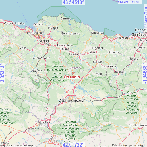
Otxandio GPS coordinates[2]
43° 1' 59.988" North, 2° 39' 0" West
| Map corner | latitude | longitude |
|---|---|---|
| Upper-left | 43.54513°, | -3.35313° |
| Center: | 43.03333°, | -2.65° |
| Lower-right: | 42.51722°, | -1.94688° |
| Map W x H: | 114.3×114.3 km | = 71×71mi |
| max Lat: | 43.74134° ⇑5.3% North |
| Otxandio: | 43.03333° |
| min Lat: | ⇓94.7% South 27.64134° |
| min Long | Otxandio | max Long |
| -18.00367° | -2.65° | 4.2899° |
| W 59.2%⇐ | ⇒40.8% E |
Elevation
Elevation of Otxandio is 580 m = 1903 ft, and this is 18 m = 59 ft below average elevation for this country.
| Max E: |
1682 m = 5518 ft | 56.2% |
| Avg. | 598 m = 1962 ft | |
| Otxandio | 580 m = 1903 ft | |
Min E: |
0 m = 0 ft | 43.8% |
See also: Spain elevation on elevation.city.
Geographical zone
Otxandio is located in North temperate zone (between Tropic of Cancer and the Arctic Circle). Distance of this Northern Tropic circle is 2178.9 km =1353.9 mi to South.| Distance of | km | miles | from Otxandio |
|---|---|---|---|
| North Pole | 5222.2 | 3244.9 | to North |
| Arctic Circle | 2616.3 | 1625.7 | to North |
| Tropic Cancer | 2178.9 | 1353.9 | to South |
| Equator | 4784.9 | 2973.2 | to South |


Nearby cities:
15 places around Otxandio: (largest is in red/bold)
• Abadiño
13.5 km =8.4 mi,  14°
14°
• Areatza
13.3 km =8.3 mi,  314°
314°
• Aretxabaleta
11.8 km =7.3 mi,  89°
89°
• Arrasate / Mondragón
13.5 km =8.4 mi,  75°
75°
• Berriz
16.3 km =10.1 mi,  24°
24°
• Durango
15.4 km =9.6 mi,  4°
4°
• Elorrio
13.9 km =8.6 mi,  39°
39°
• Eskoriatza
10.2 km =6.3 mi,  99°
99°
• Herriko Plaza
15.5 km =9.6 mi,  315°
315°
• Izurtza
13 km =8.1 mi, 5°
• Leintz-Gatzaga
8.4 km =5.2 mi,  127°
127°
• Mañaria
11.7 km =7.3 mi,  355°
355°
• Murgia
16.2 km =10.1 mi,  238°
238°
• Ubide
3.2 km =2 mi,  251°
251°
• Zeanuri
11 km =6.8 mi, 312°
Sources, notices
• [Note1] Compared only with cities in Spain existing in our database
• [Src1] Map data: © OpenStreetMap contributors (CC-BY-SA)
• [Src2] Other city data from geonames.org with taken over terms of usage.
• [Src3] Geographical zone / Annual Mean Temperature by Robert A. Rohde @ Wikipedia
