Berantevilla geodata
Berantevilla (Basque Country) is a seat of a third-order administrative division; located in Spain in Europe/Madrid (GMT+2) time zone. With population of 454 people, there are 3997 cities with bigger population in this country. Compared to other cities in Spain, 91.3% of cities are located further ↓South; 56.6% of cities are located further ←West and 64% of cities have higher elevation than Berantevilla. Note1


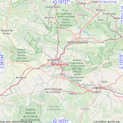
Berantevilla GPS coordinates[2]
42° 40' 57.144" North, 2° 51' 29.952" West
| Map corner | latitude | longitude |
|---|---|---|
| Upper-left | 43.19727°, | -3.56144° |
| Center: | 42.68254°, | -2.85832° |
| Lower-right: | 42.16351°, | -2.15519° |
| Map W x H: | 114.9×114.9 km | = 71.4×71.4mi |
| max Lat: | 43.74134° ⇑8.7% North |
| Berantevilla: | 42.68254° |
| min Lat: | ⇓91.3% South 27.64134° |
| min Long | Berantevilla | max Long |
| -18.00367° | -2.85832° | 4.2899° |
| W 56.6%⇐ | ⇒43.4% E |
Elevation
Elevation of Berantevilla is 473 m = 1552 ft, and this is 125 m = 410 ft below average elevation for this country.
| Max E: |
1682 m = 5518 ft | 64% |
| Avg. | 598 m = 1962 ft | |
| Berantevilla | 473 m = 1552 ft | |
Min E: |
0 m = 0 ft | 36% |
See also: Spain elevation on elevation.city.
Geographical zone
Berantevilla is located in North temperate zone (between Tropic of Cancer and the Arctic Circle). Distance of this Northern Tropic circle is 2139.9 km =1329.7 mi to South.| Distance of | km | miles | from Berantevilla |
|---|---|---|---|
| North Pole | 5261.2 | 3269.2 | to North |
| Arctic Circle | 2655.3 | 1649.9 | to North |
| Tropic Cancer | 2139.9 | 1329.7 | to South |
| Equator | 4745.9 | 2949 | to South |


Nearby cities:
15 places around Berantevilla: (largest is in red/bold)
• Anguciana
12.5 km =7.8 mi,  196°
196°
• Armiñón
4.6 km =2.9 mi,  346°
346°
• Bastida / Labastida
11.5 km =7.1 mi,  153°
153°
• Briñas
9.3 km =5.8 mi,  166°
166°
• Bugedo
13.6 km =8.5 mi,  254°
254°
• Casalarreina
15.4 km =9.6 mi, 195°
• Cellorigo
13.1 km =8.1 mi,  241°
241°
• Cihuri
14.1 km =8.8 mi, 202°
• Galbárruli
10.8 km =6.7 mi,  231°
231°
• Gimileo
15 km =9.3 mi, 168°
• Haro
11.8 km =7.3 mi,  175°
175°
• Miranda de Ebro
7.3 km =4.5 mi,  273°
273°
• Sajazarra
13.4 km =8.3 mi,  218°
218°
• Villalba de Rioja
8.4 km =5.2 mi, 196°
• Zambrana
2.9 km =1.8 mi, 215°
Sources, notices
• [Note1] Compared only with cities in Spain existing in our database
• [Src1] Map data: © OpenStreetMap contributors (CC-BY-SA)
• [Src2] Other city data from geonames.org with taken over terms of usage.
• [Src3] Geographical zone / Annual Mean Temperature by Robert A. Rohde @ Wikipedia
