Vistabella geodata
Vistabella (Aragon) is a seat of a third-order administrative division; located in Spain in Europe/Madrid (GMT+2) time zone. With population of 33 people, there are 6634 cities with bigger population in this country. Compared to other cities in Spain, 53.7% of cities are located further ↓South; 75.9% of cities are located further ←West and 59.9% of cities have lower elevation than Vistabella. Note1


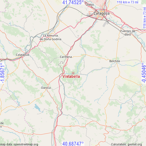
Vistabella GPS coordinates[2]
41° 13' 6.6" North, 1° 9' 12.888" West
| Map corner | latitude | longitude |
|---|---|---|
| Upper-left | 41.74525°, | -1.85671° |
| Center: | 41.2185°, | -1.15358° |
| Lower-right: | 40.68747°, | -0.45046° |
| Map W x H: | 117.6×117.6 km | = 73.1×73.1mi |
| max Lat: | 43.74134° ⇑46.3% North |
| Vistabella: | 41.2185° |
| min Lat: | ⇓53.7% South 27.64134° |
| min Long | Vistabella | max Long |
| -18.00367° | -1.15358° | 4.2899° |
| W 75.9%⇐ | ⇒24.1% E |
Elevation
Elevation of Vistabella is 744 m = 2441 ft, and this is 146 m = 479 ft above average elevation for this country.
| Max E: |
1682 m = 5518 ft | 40.1% |
| Vistabella | 744 m 2441 ft | |
| Avg. | 598 m = 1962 ft | |
Min E: |
0 m = 0 ft | 59.9% |
See also: Spain elevation on elevation.city.
Geographical zone
Vistabella is located in North temperate zone (between Tropic of Cancer and the Arctic Circle). Distance of this Northern Tropic circle is 1977.1 km =1228.5 mi to South.| Distance of | km | miles | from Vistabella |
|---|---|---|---|
| North Pole | 5424 | 3370.3 | to North |
| Arctic Circle | 2818.1 | 1751.1 | to North |
| Tropic Cancer | 1977.1 | 1228.5 | to South |
| Equator | 4583.1 | 2847.8 | to South |


Nearby cities:
15 places around Vistabella: (largest is in red/bold)
• Aguilón
12.3 km =7.6 mi,  46°
46°
• Aladrén
3.4 km =2.1 mi,  356°
356°
• Badules
12.2 km =7.6 mi,  223°
223°
• Cerveruela
5.2 km =3.2 mi,  266°
266°
• Encinacorba
12.6 km =7.8 mi,  306°
306°
• Fombuena
8.9 km =5.5 mi,  201°
201°
• Herrera de los Navarros
6 km =3.7 mi,  98°
98°
• Luesma
5.9 km =3.7 mi,  173°
173°
• Mainar
12.8 km =8 mi,  257°
257°
• Nogueras
11.8 km =7.3 mi,  142°
142°
• Paniza
8.8 km =5.5 mi,  326°
326°
• Santa Cruz de Nogueras
12.7 km =7.9 mi,  155°
155°
• Tosos
12.7 km =7.9 mi,  32°
32°
• Villar de los Navarros
11.4 km =7.1 mi,  125°
125°
• Villarreal de Huerva
11.8 km =7.3 mi,  254°
254°
Sources, notices
• [Note1] Compared only with cities in Spain existing in our database
• [Src1] Map data: © OpenStreetMap contributors (CC-BY-SA)
• [Src2] Other city data from geonames.org with taken over terms of usage.
• [Src3] Geographical zone / Annual Mean Temperature by Robert A. Rohde @ Wikipedia
