Cerveruela geodata
Cerveruela (Aragon) is a seat of a third-order administrative division; located in Spain in Europe/Madrid (GMT+2) time zone. With population of 32 people, there are 6640 cities with bigger population in this country. Compared to other cities in Spain, 53.5% of cities are located further ↓South; 75.5% of cities are located further ←West and 69.7% of cities have lower elevation than Cerveruela. Note1


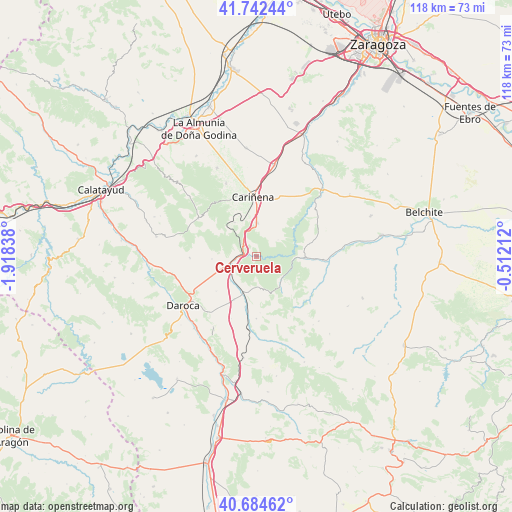
Cerveruela GPS coordinates[2]
41° 12' 56.412" North, 1° 12' 54.9" West
| Map corner | latitude | longitude |
|---|---|---|
| Upper-left | 41.74244°, | -1.91838° |
| Center: | 41.21567°, | -1.21525° |
| Lower-right: | 40.68462°, | -0.51212° |
| Map W x H: | 117.6×117.6 km | = 73.1×73.1mi |
| max Lat: | 43.74134° ⇑46.5% North |
| Cerveruela: | 41.21567° |
| min Lat: | ⇓53.5% South 27.64134° |
| min Long | Cerveruela | max Long |
| -18.00367° | -1.21525° | 4.2899° |
| W 75.5%⇐ | ⇒24.5% E |
Elevation
Elevation of Cerveruela is 812 m = 2664 ft, and this is 214 m = 702 ft above average elevation for this country.
| Max E: |
1682 m = 5518 ft | 30.3% |
| Cerveruela | 812 m 2664 ft | |
| Avg. | 598 m = 1962 ft | |
Min E: |
0 m = 0 ft | 69.7% |
See also: Spain elevation on elevation.city.
Geographical zone
Cerveruela is located in North temperate zone (between Tropic of Cancer and the Arctic Circle). Distance of this Northern Tropic circle is 1976.8 km =1228.3 mi to South.| Distance of | km | miles | from Cerveruela |
|---|---|---|---|
| North Pole | 5424.3 | 3370.5 | to North |
| Arctic Circle | 2818.4 | 1751.3 | to North |
| Tropic Cancer | 1976.8 | 1228.3 | to South |
| Equator | 4582.8 | 2847.6 | to South |


Nearby cities:
15 places around Cerveruela: (largest is in red/bold)
• Aladrén
6.2 km =3.9 mi,  53°
53°
• Badules
9.1 km =5.7 mi,  200°
200°
• Encinacorba
9.2 km =5.7 mi,  327°
327°
• Fombuena
8.1 km =5 mi,  166°
166°
• Herrera de los Navarros
11.1 km =6.9 mi,  93°
93°
• Luesma
8 km =5 mi,  133°
133°
• Mainar
7.8 km =4.8 mi,  250°
250°
• Paniza
7.6 km =4.7 mi,  1°
1°
• Romanos
11.1 km =6.9 mi,  206°
206°
• Torralbilla
10.3 km =6.4 mi,  266°
266°
• Villadoz
8.5 km =5.3 mi,  225°
225°
• Villahermosa del Campo
12.1 km =7.5 mi,  192°
192°
• Villarreal de Huerva
6.8 km =4.2 mi, 245°
• Villarroya del Campo
12.2 km =7.6 mi, 228°
• Vistabella
5.2 km =3.2 mi, 86°
Sources, notices
• [Note1] Compared only with cities in Spain existing in our database
• [Src1] Map data: © OpenStreetMap contributors (CC-BY-SA)
• [Src2] Other city data from geonames.org with taken over terms of usage.
• [Src3] Geographical zone / Annual Mean Temperature by Robert A. Rohde @ Wikipedia
