Aguilón geodata
Aguilón (Aragon) is a seat of a third-order administrative division; located in Spain in Europe/Madrid (GMT+2) time zone. With population of 288 people, there are 4552 cities with bigger population in this country. Compared to other cities in Spain, 55.3% of cities are located further ↓South; 76.8% of cities are located further ←West and 52.7% of cities have lower elevation than Aguilón. Note1


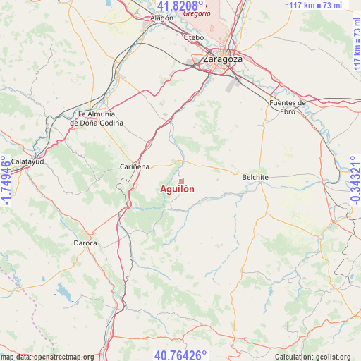
Aguilón GPS coordinates[2]
41° 17' 40.812" North, 1° 2' 46.824" West
| Map corner | latitude | longitude |
|---|---|---|
| Upper-left | 41.8208°, | -1.74946° |
| Center: | 41.29467°, | -1.04634° |
| Lower-right: | 40.76426°, | -0.34321° |
| Map W x H: | 117.5×117.5 km | = 73×73mi |
| max Lat: | 43.74134° ⇑44.7% North |
| Aguilón: | 41.29467° |
| min Lat: | ⇓55.3% South 27.64134° |
| min Long | Aguilón | max Long |
| -18.00367° | -1.04634° | 4.2899° |
| W 76.8%⇐ | ⇒23.2% E |
Elevation
Elevation of Aguilón is 687 m = 2254 ft, and this is 89 m = 292 ft above average elevation for this country.
| Max E: |
1682 m = 5518 ft | 47.3% |
| Aguilón | 687 m 2254 ft | |
| Avg. | 598 m = 1962 ft | |
Min E: |
0 m = 0 ft | 52.7% |
See also: Spain elevation on elevation.city.
Geographical zone
Aguilón is located in North temperate zone (between Tropic of Cancer and the Arctic Circle). Distance of this Northern Tropic circle is 1985.6 km =1233.8 mi to South.| Distance of | km | miles | from Aguilón |
|---|---|---|---|
| North Pole | 5415.5 | 3365 | to North |
| Arctic Circle | 2809.6 | 1745.8 | to North |
| Tropic Cancer | 1985.6 | 1233.8 | to South |
| Equator | 4591.5 | 2853 | to South |


Nearby cities:
15 places around Aguilón: (largest is in red/bold)
• Aladrén
10.5 km =6.5 mi,  241°
241°
• Azuara
15.2 km =9.4 mi,  105°
105°
• Cariñena
15.6 km =9.7 mi,  287°
287°
• Cerveruela
16.6 km =10.3 mi, 238°
• Fuendetodos
9 km =5.6 mi,  53°
53°
• Herrera de los Navarros
9.9 km =6.2 mi,  197°
197°
• Longares
15.8 km =9.8 mi,  319°
319°
• Luesma
16.6 km =10.3 mi,  210°
210°
• Mezalocha
14.9 km =9.3 mi,  348°
348°
• Nogueras
17.9 km =11.1 mi,  185°
185°
• Paniza
13.9 km =8.6 mi,  265°
265°
• Tosos
3.2 km =2 mi, 316°
• Villanueva del Huerva
6.6 km =4.1 mi,  7°
7°
• Villar de los Navarros
15 km =9.3 mi,  178°
178°
• Vistabella
12.3 km =7.6 mi,  226°
226°
Sources, notices
• [Note1] Compared only with cities in Spain existing in our database
• [Src1] Map data: © OpenStreetMap contributors (CC-BY-SA)
• [Src2] Other city data from geonames.org with taken over terms of usage.
• [Src3] Geographical zone / Annual Mean Temperature by Robert A. Rohde @ Wikipedia
