Encinacorba geodata
Encinacorba (Aragon) is a seat of a third-order administrative division; located in Spain in Europe/Madrid (GMT+2) time zone. With population of 283 people, there are 4576 cities with bigger population in this country. Compared to other cities in Spain, 55.1% of cities are located further ↓South; 75% of cities are located further ←West and 61.5% of cities have lower elevation than Encinacorba. Note1


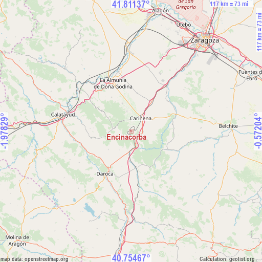
Encinacorba GPS coordinates[2]
41° 17' 6.576" North, 1° 16' 30.576" West
| Map corner | latitude | longitude |
|---|---|---|
| Upper-left | 41.81137°, | -1.97829° |
| Center: | 41.28516°, | -1.27516° |
| Lower-right: | 40.75467°, | -0.57204° |
| Map W x H: | 117.5×117.5 km | = 73×73mi |
| max Lat: | 43.74134° ⇑44.9% North |
| Encinacorba: | 41.28516° |
| min Lat: | ⇓55.1% South 27.64134° |
| min Long | Encinacorba | max Long |
| -18.00367° | -1.27516° | 4.2899° |
| W 75%⇐ | ⇒25% E |
Elevation
Elevation of Encinacorba is 754 m = 2474 ft, and this is 156 m = 512 ft above average elevation for this country.
| Max E: |
1682 m = 5518 ft | 38.5% |
| Encinacorba | 754 m 2474 ft | |
| Avg. | 598 m = 1962 ft | |
Min E: |
0 m = 0 ft | 61.5% |
See also: Spain elevation on elevation.city.
Geographical zone
Encinacorba is located in North temperate zone (between Tropic of Cancer and the Arctic Circle). Distance of this Northern Tropic circle is 1984.6 km =1233.2 mi to South.| Distance of | km | miles | from Encinacorba |
|---|---|---|---|
| North Pole | 5416.6 | 3365.7 | to North |
| Arctic Circle | 2810.7 | 1746.5 | to North |
| Tropic Cancer | 1984.6 | 1233.2 | to South |
| Equator | 4590.5 | 2852.4 | to South |


Nearby cities:
15 places around Encinacorba: (largest is in red/bold)
• Aguarón
6 km =3.7 mi,  3°
3°
• Aladrén
10.7 km =6.6 mi,  111°
111°
• Almonacid de la Sierra
13.1 km =8.1 mi,  341°
341°
• Cariñena
7.2 km =4.5 mi,  36°
36°
• Cerveruela
9.2 km =5.7 mi,  147°
147°
• Codos
8.3 km =5.2 mi,  275°
275°
• Cosuenda
9.2 km =5.7 mi,  347°
347°
• Langa del Castillo
13.1 km =8.1 mi,  231°
231°
• Mainar
10.5 km =6.5 mi,  192°
192°
• Paniza
5.3 km =3.3 mi,  91°
91°
• Tobed
12 km =7.5 mi,  299°
299°
• Torralbilla
9.9 km =6.2 mi,  212°
212°
• Villadoz
13.7 km =8.5 mi,  184°
184°
• Villarreal de Huerva
10.6 km =6.6 mi, 186°
• Vistabella
12.6 km =7.8 mi,  126°
126°
Sources, notices
• [Note1] Compared only with cities in Spain existing in our database
• [Src1] Map data: © OpenStreetMap contributors (CC-BY-SA)
• [Src2] Other city data from geonames.org with taken over terms of usage.
• [Src3] Geographical zone / Annual Mean Temperature by Robert A. Rohde @ Wikipedia
