Peníscola geodata
Peníscola (Valencia) is a populated place; located in Spain in Europe/Madrid (GMT+2) time zone. With population of 6,006 people, there are 1139 cities with bigger population in this country. Compared to other cities in Spain, 64.8% of cities are located further ↑North; 88.6% of cities are located further ←West and 95.6% of cities have higher elevation than Peníscola. Note1
Administrative division(s):
- Level 1: Valencia
- Level 2: Província de Castelló
- Level 3: Peníscola/Peñíscola


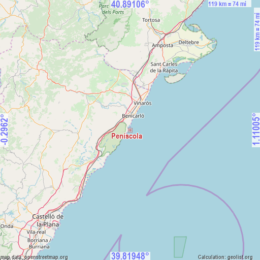
Peníscola GPS coordinates[2]
40° 21' 26.64" North, 0° 24' 24.912" East
| Map corner | latitude | longitude |
|---|---|---|
| Upper-left | 40.89106°, | -0.2962° |
| Center: | 40.3574°, | 0.40692° |
| Lower-right: | 39.81948°, | 1.11005° |
| Map W x H: | 119.1×119.1 km | = 74×74mi |
| max Lat: | 43.74134° ⇑64.8% North |
| Peníscola: | 40.3574° |
| min Lat: | ⇓35.2% South 27.64134° |
| min Long | Peníscola | max Long |
| -18.00367° | 0.40692° | 4.2899° |
| W 88.6%⇐ | ⇒11.4% E |
Elevation
Elevation of Peníscola is 22 m = 72 ft, and this is 576 m = 1890 ft below average elevation for this country.
| Max E: |
1682 m = 5518 ft | 95.6% |
| Avg. | 598 m = 1962 ft | |
| Peníscola | 22 m = 72 ft | |
Min E: |
0 m = 0 ft | 4.4% |
See also: Spain elevation on elevation.city.
Geographical zone
Peníscola is located in North temperate zone (between Tropic of Cancer and the Arctic Circle). Distance of this Northern Tropic circle is 1881.4 km =1169 mi to South.| Distance of | km | miles | from Peníscola |
|---|---|---|---|
| North Pole | 5519.7 | 3429.8 | to North |
| Arctic Circle | 2913.9 | 1810.6 | to North |
| Tropic Cancer | 1881.4 | 1169 | to South |
| Equator | 4487.3 | 2788.3 | to South |


Nearby cities:
15 places around Peníscola: (largest is in red/bold)
• Alcalà de Xivert
16 km =9.9 mi,  246°
246°
• Alcanar
21.6 km =13.4 mi,  16°
16°
• Alcocéber
15.7 km =9.8 mi,  221°
221°
• Benicarló
6.8 km =4.2 mi,  14°
14°
• Canet lo Roig
25.6 km =15.9 mi,  327°
327°
• Cervera del Maestre
15.4 km =9.6 mi,  314°
314°
• Cuevas de Vinromá
24.8 km =15.4 mi,  257°
257°
• Càlig
12.5 km =7.8 mi,  339°
339°
• Les Cases d'Alcanar
24.2 km =15 mi,  25°
25°
• Salsadella
20.8 km =12.9 mi,  288°
288°
• Sant Jordi
18.1 km =11.2 mi, 339°
• Santa Magdalena de Pulpis
8.8 km =5.5 mi,  269°
269°
• Torreblanca
23.5 km =14.6 mi,  229°
229°
• Traiguera
21.1 km =13.1 mi, 332°
• Vinaròs
13.8 km =8.6 mi, 24°
Sources, notices
• [Note1] Compared only with cities in Spain existing in our database
• [Src1] Map data: © OpenStreetMap contributors (CC-BY-SA)
• [Src2] Other city data from geonames.org with taken over terms of usage.
• [Src3] Geographical zone / Annual Mean Temperature by Robert A. Rohde @ Wikipedia
