Canet lo Roig geodata
Canet lo Roig (Valencia) is a seat of a third-order administrative division; located in Spain in Europe/Madrid (GMT+2) time zone. With population of 903 people, there are 3065 cities with bigger population in this country. Compared to other cities in Spain, 60.8% of cities are located further ↑North; 88.1% of cities are located further ←West and 73% of cities have higher elevation than Canet lo Roig. Note1


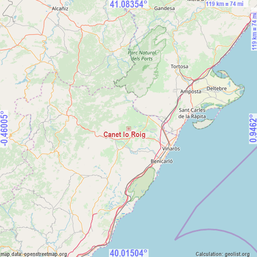
Canet lo Roig GPS coordinates[2]
40° 33' 5.112" North, 0° 14' 35.088" East
| Map corner | latitude | longitude |
|---|---|---|
| Upper-left | 41.08354°, | -0.46005° |
| Center: | 40.55142°, | 0.24308° |
| Lower-right: | 40.01504°, | 0.9462° |
| Map W x H: | 118.8×118.8 km | = 73.8×73.8mi |
| max Lat: | 43.74134° ⇑60.8% North |
| Canet lo Roig: | 40.55142° |
| min Lat: | ⇓39.2% South 27.64134° |
| min Long | Canet lo Roig | max Long |
| -18.00367° | 0.24308° | 4.2899° |
| W 88.1%⇐ | ⇒11.9% E |
Elevation
Elevation of Canet lo Roig is 333 m = 1093 ft, and this is 265 m = 869 ft below average elevation for this country.
| Max E: |
1682 m = 5518 ft | 73% |
| Avg. | 598 m = 1962 ft | |
| Canet lo Roig | 333 m = 1093 ft | |
Min E: |
0 m = 0 ft | 27% |
See also: Spain elevation on elevation.city.
Geographical zone
Canet lo Roig is located in North temperate zone (between Tropic of Cancer and the Arctic Circle). Distance of this Northern Tropic circle is 1903 km =1182.5 mi to South.| Distance of | km | miles | from Canet lo Roig |
|---|---|---|---|
| North Pole | 5498.2 | 3416.4 | to North |
| Arctic Circle | 2892.3 | 1797.2 | to North |
| Tropic Cancer | 1903 | 1182.5 | to South |
| Equator | 4508.9 | 2801.7 | to South |


Nearby cities:
15 places around Canet lo Roig: (largest is in red/bold)
• Alcanar
20.1 km =12.5 mi,  92°
92°
• Castell de Cabres
20.9 km =13 mi,  305°
305°
• Catí
20.6 km =12.8 mi,  244°
244°
• Cervera del Maestre
11.2 km =7 mi,  165°
165°
• Chert/Xert
8 km =5 mi, 243°
• Càlig
13.7 km =8.5 mi,  136°
136°
• Rosell
7.6 km =4.7 mi,  346°
346°
• Salsadella
15.9 km =9.9 mi,  201°
201°
• Sant Jordi
8.8 km =5.5 mi,  121°
121°
• Sant Rafel del Maestrat
10.5 km =6.5 mi,  59°
59°
• Tirig
20 km =12.4 mi,  224°
224°
• Traiguera
4.9 km =3 mi,  126°
126°
• Ulldecona
18 km =11.2 mi,  73°
73°
• Vallibona
17.6 km =10.9 mi,  289°
289°
• Vinaròs
21.6 km =13.4 mi,  114°
114°
Sources, notices
• [Note1] Compared only with cities in Spain existing in our database
• [Src1] Map data: © OpenStreetMap contributors (CC-BY-SA)
• [Src2] Other city data from geonames.org with taken over terms of usage.
• [Src3] Geographical zone / Annual Mean Temperature by Robert A. Rohde @ Wikipedia
