Igüeña geodata
Igüeña (Castille and León) is a seat of a third-order administrative division; located in Spain in Europe/Madrid (GMT+2) time zone. With population of 1,633 people, there are 2382 cities with bigger population in this country. Compared to other cities in Spain, 91.9% of cities are located further ↓South; 89.3% of cities are located further →East and 81.6% of cities have lower elevation than Igüeña. Note1


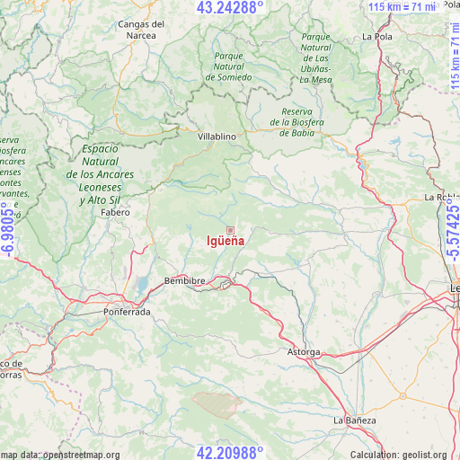
Igüeña GPS coordinates[2]
42° 43' 42.708" North, 6° 16' 38.568" West
| Map corner | latitude | longitude |
|---|---|---|
| Upper-left | 43.24288°, | -6.9805° |
| Center: | 42.72853°, | -6.27738° |
| Lower-right: | 42.20988°, | -5.57425° |
| Map W x H: | 114.9×114.9 km | = 71.4×71.4mi |
| max Lat: | 43.74134° ⇑8.1% North |
| Igüeña: | 42.72853° |
| min Lat: | ⇓91.9% South 27.64134° |
| min Long | Igüeña | max Long |
| -18.00367° | -6.27738° | 4.2899° |
| W 10.7%⇐ | ⇒89.3% E |
Elevation
Elevation of Igüeña is 913 m = 2995 ft, and this is 315 m = 1033 ft above average elevation for this country.
| Max E: |
1682 m = 5518 ft | 18.4% |
| Igüeña | 913 m 2995 ft | |
| Avg. | 598 m = 1962 ft | |
Min E: |
0 m = 0 ft | 81.6% |
See also: Spain elevation on elevation.city.
Geographical zone
Igüeña is located in North temperate zone (between Tropic of Cancer and the Arctic Circle). Distance of this Northern Tropic circle is 2145 km =1332.8 mi to South.| Distance of | km | miles | from Igüeña |
|---|---|---|---|
| North Pole | 5256.1 | 3266 | to North |
| Arctic Circle | 2650.2 | 1646.8 | to North |
| Tropic Cancer | 2145 | 1332.8 | to South |
| Equator | 4751 | 2952.1 | to South |


Nearby cities:
15 places around Igüeña: (largest is in red/bold)
• Bembibre
16.7 km =10.4 mi,  222°
222°
• Berlanga del Bierzo
26.8 km =16.7 mi,  270°
270°
• Castropodame
22.8 km =14.2 mi, 223°
• Congosto
23.4 km =14.5 mi,  238°
238°
• Cubillos del Sil
26.1 km =16.2 mi, 243°
• Folgoso de la Ribera
9.7 km =6 mi,  201°
201°
• Murias de Paredes
15.2 km =9.4 mi,  27°
27°
• Palacios del Sil
20.7 km =12.9 mi,  322°
322°
• Páramo del Sil
20 km =12.4 mi,  300°
300°
• Quintana del Castillo
20.1 km =12.5 mi,  112°
112°
• Toreno
19.5 km =12.1 mi,  260°
260°
• Torre del Bierzo
15.3 km =9.5 mi,  208°
208°
• Valdesamario
26.7 km =16.6 mi,  91°
91°
• Villablino
23.7 km =14.7 mi,  351°
351°
• Villagatón
14.1 km =8.8 mi,  138°
138°
Sources, notices
• [Note1] Compared only with cities in Spain existing in our database
• [Src1] Map data: © OpenStreetMap contributors (CC-BY-SA)
• [Src2] Other city data from geonames.org with taken over terms of usage.
• [Src3] Geographical zone / Annual Mean Temperature by Robert A. Rohde @ Wikipedia
