Villafranca del Cid geodata
Villafranca del Cid (Valencia) is a populated place; located in Spain in Europe/Madrid (GMT+2) time zone. With population of 2,562 people, there are 1876 cities with bigger population in this country. Compared to other cities in Spain, 63.4% of cities are located further ↑North; 85% of cities are located further ←West and 94.7% of cities have lower elevation than Villafranca del Cid. Note1
Administrative division(s):
- Level 1: Valencia
- Level 2: Província de Castelló
- Level 3: Villafranca del Cid/Vilafranca


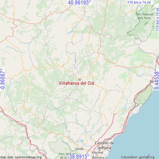
Villafranca del Cid GPS coordinates[2]
40° 25' 43.86" North, 0° 15' 27.9" West
| Map corner | latitude | longitude |
|---|---|---|
| Upper-left | 40.96195°, | -0.96087° |
| Center: | 40.42885°, | -0.25775° |
| Lower-right: | 39.8915°, | 0.44538° |
| Map W x H: | 119×119 km | = 73.9×73.9mi |
| max Lat: | 43.74134° ⇑63.4% North |
| Villafranca del Cid: | 40.42885° |
| min Lat: | ⇓36.6% South 27.64134° |
| min Long | Villafranca del | max Long |
| -18.00367° | -0.25775° | 4.2899° |
| W 85%⇐ | ⇒15% E |
Elevation
Elevation of Villafranca del Cid is 1130 m = 3707 ft, and this is 532 m = 1745 ft above average elevation for this country.
| Max E: |
1682 m = 5518 ft | 5.3% |
| Villafranca del Cid | 1130 m 3707 ft | |
| Avg. | 598 m = 1962 ft | |
Min E: |
0 m = 0 ft | 94.7% |
See also: Spain elevation on elevation.city.
Geographical zone
Villafranca del Cid is located in North temperate zone (between Tropic of Cancer and the Arctic Circle). Distance of this Northern Tropic circle is 1889.3 km =1174 mi to South.| Distance of | km | miles | from Villafranca del Cid |
|---|---|---|---|
| North Pole | 5511.8 | 3424.9 | to North |
| Arctic Circle | 2905.9 | 1805.6 | to North |
| Tropic Cancer | 1889.3 | 1174 | to South |
| Equator | 4495.3 | 2793.2 | to South |


Nearby cities:
15 places around Villafranca del Cid: (largest is in red/bold)
• Ares del Maestre
11 km =6.8 mi,  73°
73°
• Benafigos
17.5 km =10.9 mi,  165°
165°
• Benassal
11.5 km =7.1 mi,  120°
120°
• Cantavieja
16.6 km =10.3 mi,  310°
310°
• Castellfort
9.9 km =6.2 mi,  34°
34°
• Catí
24.2 km =15 mi,  78°
78°
• Cinctorres
17.5 km =10.9 mi,  11°
11°
• Culla
12.9 km =8 mi,  142°
142°
• Fortanete
24 km =14.9 mi,  290°
290°
• La Iglesuela del Cid
8 km =5 mi,  319°
319°
• Mirambel
19 km =11.8 mi,  337°
337°
• Mosqueruela
17.8 km =11.1 mi,  245°
245°
• Portell de Morella
11.6 km =7.2 mi,  358°
358°
• Todolella
24.2 km =15 mi,  2°
2°
• Vistabella del Maestrazgo
15.1 km =9.4 mi,  191°
191°
Sources, notices
• [Note1] Compared only with cities in Spain existing in our database
• [Src1] Map data: © OpenStreetMap contributors (CC-BY-SA)
• [Src2] Other city data from geonames.org with taken over terms of usage.
• [Src3] Geographical zone / Annual Mean Temperature by Robert A. Rohde @ Wikipedia
