Castellfort geodata
Castellfort (Valencia) is a seat of a third-order administrative division; located in Spain in Europe/Madrid (GMT+2) time zone. With population of 216 people, there are 4946 cities with bigger population in this country. Compared to other cities in Spain, 61.8% of cities are located further ↑North; 85.6% of cities are located further ←West and 95.7% of cities have lower elevation than Castellfort. Note1


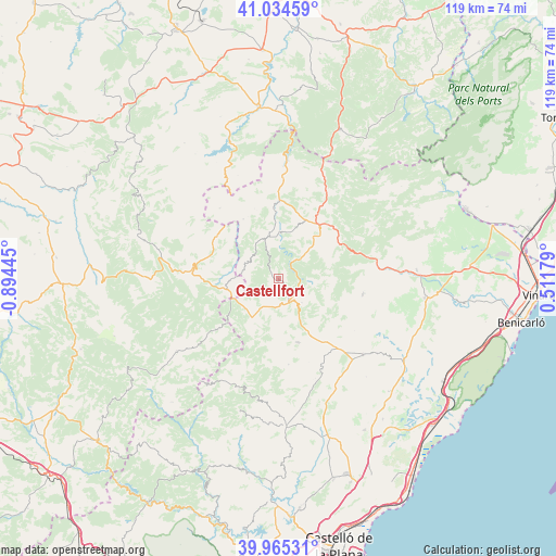
Castellfort GPS coordinates[2]
40° 30' 7.488" North, 0° 11' 28.788" West
| Map corner | latitude | longitude |
|---|---|---|
| Upper-left | 41.03459°, | -0.89445° |
| Center: | 40.50208°, | -0.19133° |
| Lower-right: | 39.96531°, | 0.51179° |
| Map W x H: | 118.9×118.9 km | = 73.9×73.9mi |
| max Lat: | 43.74134° ⇑61.8% North |
| Castellfort: | 40.50208° |
| min Lat: | ⇓38.2% South 27.64134° |
| min Long | Castellfort | max Long |
| -18.00367° | -0.19133° | 4.2899° |
| W 85.6%⇐ | ⇒14.4% E |
Elevation
Elevation of Castellfort is 1156 m = 3793 ft, and this is 558 m = 1831 ft above average elevation for this country.
| Max E: |
1682 m = 5518 ft | 4.3% |
| Castellfort | 1156 m 3793 ft | |
| Avg. | 598 m = 1962 ft | |
Min E: |
0 m = 0 ft | 95.7% |
See also: Spain elevation on elevation.city.
Geographical zone
Castellfort is located in North temperate zone (between Tropic of Cancer and the Arctic Circle). Distance of this Northern Tropic circle is 1897.5 km =1179.1 mi to South.| Distance of | km | miles | from Castellfort |
|---|---|---|---|
| North Pole | 5503.7 | 3419.8 | to North |
| Arctic Circle | 2897.8 | 1800.6 | to North |
| Tropic Cancer | 1897.5 | 1179.1 | to South |
| Equator | 4503.4 | 2798.3 | to South |


Nearby cities:
15 places around Castellfort: (largest is in red/bold)
• Ares del Maestre
7.1 km =4.4 mi,  135°
135°
• Benassal
14.6 km =9.1 mi,  162°
162°
• Cantavieja
18.3 km =11.4 mi,  278°
278°
• Catí
18.4 km =11.4 mi,  100°
100°
• Cinctorres
9.3 km =5.8 mi,  346°
346°
• Culla
18.5 km =11.5 mi,  173°
173°
• Forcall
16 km =9.9 mi,  357°
357°
• La Iglesuela del Cid
11 km =6.8 mi,  258°
258°
• Mirambel
15.9 km =9.9 mi,  306°
306°
• Morella
15.2 km =9.4 mi,  30°
30°
• Olocau del Rey
19.6 km =12.2 mi,  320°
320°
• Portell de Morella
6.9 km =4.3 mi,  299°
299°
• Todolella
16.8 km =10.4 mi,  343°
343°
• Villafranca del Cid
9.9 km =6.2 mi,  214°
214°
• Villores
19.2 km =11.9 mi, 357°
Sources, notices
• [Note1] Compared only with cities in Spain existing in our database
• [Src1] Map data: © OpenStreetMap contributors (CC-BY-SA)
• [Src2] Other city data from geonames.org with taken over terms of usage.
• [Src3] Geographical zone / Annual Mean Temperature by Robert A. Rohde @ Wikipedia
