Benafigos geodata
Benafigos (Valencia) is a seat of a third-order administrative division; located in Spain in Europe/Madrid (GMT+2) time zone. With population of 180 people, there are 5185 cities with bigger population in this country. Compared to other cities in Spain, 66.1% of cities are located further ↑North; 85.5% of cities are located further ←West and 82.1% of cities have lower elevation than Benafigos. Note1


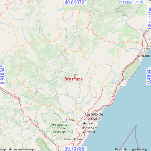
Benafigos GPS coordinates[2]
40° 16' 35.076" North, 0° 12' 27.792" West
| Map corner | latitude | longitude |
|---|---|---|
| Upper-left | 40.81072°, | -0.91084° |
| Center: | 40.27641°, | -0.20772° |
| Lower-right: | 39.73785°, | 0.4954° |
| Map W x H: | 119.3×119.3 km | = 74.1×74.1mi |
| max Lat: | 43.74134° ⇑66.1% North |
| Benafigos: | 40.27641° |
| min Lat: | ⇓33.9% South 27.64134° |
| min Long | Benafigos | max Long |
| -18.00367° | -0.20772° | 4.2899° |
| W 85.5%⇐ | ⇒14.5% E |
Elevation
Elevation of Benafigos is 918 m = 3012 ft, and this is 320 m = 1050 ft above average elevation for this country.
| Max E: |
1682 m = 5518 ft | 17.9% |
| Benafigos | 918 m 3012 ft | |
| Avg. | 598 m = 1962 ft | |
Min E: |
0 m = 0 ft | 82.1% |
See also: Spain elevation on elevation.city.
Geographical zone
Benafigos is located in North temperate zone (between Tropic of Cancer and the Arctic Circle). Distance of this Northern Tropic circle is 1872.4 km =1163.5 mi to South.| Distance of | km | miles | from Benafigos |
|---|---|---|---|
| North Pole | 5528.7 | 3435.4 | to North |
| Arctic Circle | 2922.9 | 1816.2 | to North |
| Tropic Cancer | 1872.4 | 1163.5 | to South |
| Equator | 4478.3 | 2782.7 | to South |


Nearby cities:
15 places around Benafigos: (largest is in red/bold)
• Adzaneta
7.4 km =4.6 mi,  154°
154°
• Ares del Maestre
21 km =13 mi,  17°
17°
• Benassal
12.6 km =7.8 mi,  27°
27°
• Benlloch
21.2 km =13.2 mi,  110°
110°
• Costur
17.7 km =11 mi,  170°
170°
• Culla
7.6 km =4.7 mi, 28°
• Figueroles
17.9 km =11.1 mi,  186°
186°
• Lucena del Cid
17.2 km =10.7 mi,  201°
201°
• Puertomingalvo
21.2 km =13.2 mi,  266°
266°
• Sarratella
20.7 km =12.9 mi,  78°
78°
• Sierra-Engarcerán
16 km =9.9 mi,  92°
92°
• Useras
13.7 km =8.5 mi,  164°
164°
• Villafranca del Cid
17.5 km =10.9 mi,  345°
345°
• Villahermosa del Río
19.8 km =12.3 mi,  245°
245°
• Vistabella del Maestrazgo
7.7 km =4.8 mi,  286°
286°
Sources, notices
• [Note1] Compared only with cities in Spain existing in our database
• [Src1] Map data: © OpenStreetMap contributors (CC-BY-SA)
• [Src2] Other city data from geonames.org with taken over terms of usage.
• [Src3] Geographical zone / Annual Mean Temperature by Robert A. Rohde @ Wikipedia
