Villaflor geodata
Villaflor (Castille and León) is a seat of a third-order administrative division; located in Spain in Europe/Madrid (GMT+2) time zone. With population of 143 people, there are 5475 cities with bigger population in this country. Compared to other cities in Spain, 57% of cities are located further ↑North; 70.8% of cities are located further →East and 87% of cities have lower elevation than Villaflor. Note1
Administrative division(s):
- Level 1: Castille and León
- Level 2: Provincia de Ávila
- Level 3: Villaflor


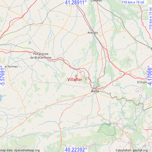
Villaflor GPS coordinates[2]
40° 45' 31.14" North, 4° 52' 25.644" West
| Map corner | latitude | longitude |
|---|---|---|
| Upper-left | 41.28911°, | -5.57691° |
| Center: | 40.75865°, | -4.87379° |
| Lower-right: | 40.22392°, | -4.17066° |
| Map W x H: | 118.4×118.4 km | = 73.6×73.6mi |
| max Lat: | 43.74134° ⇑57% North |
| Villaflor: | 40.75865° |
| min Lat: | ⇓43% South 27.64134° |
| min Long | Villaflor | max Long |
| -18.00367° | -4.87379° | 4.2899° |
| W 29.2%⇐ | ⇒70.8% E |
Elevation
Elevation of Villaflor is 981 m = 3219 ft, and this is 383 m = 1257 ft above average elevation for this country.
| Max E: |
1682 m = 5518 ft | 13% |
| Villaflor | 981 m 3219 ft | |
| Avg. | 598 m = 1962 ft | |
Min E: |
0 m = 0 ft | 87% |
See also: Spain elevation on elevation.city.
Geographical zone
Villaflor is located in North temperate zone (between Tropic of Cancer and the Arctic Circle). Distance of this Northern Tropic circle is 1926 km =1196.8 mi to South.| Distance of | km | miles | from Villaflor |
|---|---|---|---|
| North Pole | 5475.1 | 3402.1 | to North |
| Arctic Circle | 2869.2 | 1782.8 | to North |
| Tropic Cancer | 1926 | 1196.8 | to South |
| Equator | 4531.9 | 2816 | to South |


Nearby cities:
15 places around Villaflor: (largest is in red/bold)
• Albornos
8.8 km =5.5 mi,  355°
355°
• Aveinte
4.1 km =2.5 mi,  50°
50°
• Brabos
5.9 km =3.7 mi,  291°
291°
• Cardeñosa
10.9 km =6.8 mi,  99°
99°
• Chamartín
9.4 km =5.8 mi,  228°
228°
• Cillán
10.7 km =6.6 mi,  237°
237°
• Monsalupe
7.9 km =4.9 mi,  81°
81°
• Muñogrande
8.1 km =5 mi,  329°
329°
• Peñalba de Ávila
10.9 km =6.8 mi, 81°
• San Juan de la Encinilla
8.5 km =5.3 mi,  19°
19°
• San Pedro del Arroyo
4.8 km =3 mi,  3°
3°
• Sanchorreja
11 km =6.8 mi,  198°
198°
• Santo Tomé de Zabarcos
4.4 km =2.7 mi,  315°
315°
• Sigeres
6.8 km =4.2 mi,  311°
311°
• Viñegra de Moraña
11 km =6.8 mi,  338°
338°
Sources, notices
• [Note1] Compared only with cities in Spain existing in our database
• [Src1] Map data: © OpenStreetMap contributors (CC-BY-SA)
• [Src2] Other city data from geonames.org with taken over terms of usage.
• [Src3] Geographical zone / Annual Mean Temperature by Robert A. Rohde @ Wikipedia
