Peñalba de Ávila geodata
Peñalba de Ávila (Castille and León) is a seat of a third-order administrative division; located in Spain in Europe/Madrid (GMT+2) time zone. With population of 130 people, there are 5579 cities with bigger population in this country. Compared to other cities in Spain, 56.7% of cities are located further ↑North; 69.1% of cities are located further →East and 91.7% of cities have lower elevation than Peñalba de Ávila. Note1
Administrative division(s):
- Level 1: Castille and León
- Level 2: Provincia de Ávila
- Level 3: Peñalba de Ávila


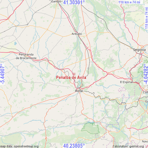
Peñalba de Ávila GPS coordinates[2]
40° 46' 21.576" North, 4° 44' 45.42" West
| Map corner | latitude | longitude |
|---|---|---|
| Upper-left | 41.30301°, | -5.44907° |
| Center: | 40.77266°, | -4.74595° |
| Lower-right: | 40.23805°, | -4.04282° |
| Map W x H: | 118.4×118.4 km | = 73.6×73.6mi |
| max Lat: | 43.74134° ⇑56.7% North |
| Peñalba de Ávila: | 40.77266° |
| min Lat: | ⇓43.3% South 27.64134° |
| min Long | Peñalba de Áv | max Long |
| -18.00367° | -4.74595° | 4.2899° |
| W 30.9%⇐ | ⇒69.1% E |
Elevation
Elevation of Peñalba de Ávila is 1062 m = 3484 ft, and this is 464 m = 1522 ft above average elevation for this country.
| Max E: |
1682 m = 5518 ft | 8.3% |
| Peñalba de Ávila | 1062 m 3484 ft | |
| Avg. | 598 m = 1962 ft | |
Min E: |
0 m = 0 ft | 91.7% |
See also: Spain elevation on elevation.city.
Geographical zone
Peñalba de Ávila is located in North temperate zone (between Tropic of Cancer and the Arctic Circle). Distance of this Northern Tropic circle is 1927.6 km =1197.8 mi to South.| Distance of | km | miles | from Peñalba de Ávila |
|---|---|---|---|
| North Pole | 5473.6 | 3401.1 | to North |
| Arctic Circle | 2867.7 | 1781.9 | to North |
| Tropic Cancer | 1927.6 | 1197.8 | to South |
| Equator | 4533.5 | 2817 | to South |


Nearby cities:
15 places around Peñalba de Ávila: (largest is in red/bold)
• Aveinte
7.7 km =4.8 mi,  277°
277°
• Cardeñosa
3.4 km =2.1 mi,  179°
179°
• Gotarrendura
6 km =3.7 mi,  4°
4°
• Hernansancho
9.5 km =5.9 mi,  7°
7°
• Martiherrero
11.4 km =7.1 mi,  195°
195°
• Mingorría
7.1 km =4.4 mi,  108°
108°
• Monsalupe
3 km =1.9 mi,  263°
263°
• Pozanco
7.3 km =4.5 mi,  64°
64°
• San Esteban de los Patos
10.6 km =6.6 mi, 105°
• San Juan de la Encinilla
10.2 km =6.3 mi,  309°
309°
• San Pascual
12.1 km =7.5 mi,  355°
355°
• San Pedro del Arroyo
11 km =6.8 mi,  287°
287°
• Santo Domingo de las Posadas
10.4 km =6.5 mi,  65°
65°
• Vega de Santa María
11.2 km =7 mi,  50°
50°
• Villaflor
10.9 km =6.8 mi, 261°
Sources, notices
• [Note1] Compared only with cities in Spain existing in our database
• [Src1] Map data: © OpenStreetMap contributors (CC-BY-SA)
• [Src2] Other city data from geonames.org with taken over terms of usage.
• [Src3] Geographical zone / Annual Mean Temperature by Robert A. Rohde @ Wikipedia
