Monsalupe geodata
Monsalupe (Castille and León) is a seat of a third-order administrative division; located in Spain in Europe/Madrid (GMT+2) time zone. With population of 69 people, there are 6254 cities with bigger population in this country. Compared to other cities in Spain, 56.8% of cities are located further ↑North; 69.4% of cities are located further →East and 88.3% of cities have lower elevation than Monsalupe. Note1
Administrative division(s):
- Level 1: Castille and León
- Level 2: Provincia de Ávila
- Level 3: Monsalupe


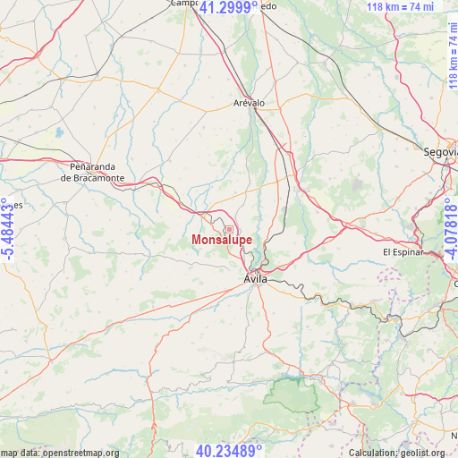
Monsalupe GPS coordinates[2]
40° 46' 10.308" North, 4° 46' 52.716" West
| Map corner | latitude | longitude |
|---|---|---|
| Upper-left | 41.2999°, | -5.48443° |
| Center: | 40.76953°, | -4.78131° |
| Lower-right: | 40.23489°, | -4.07818° |
| Map W x H: | 118.4×118.4 km | = 73.6×73.6mi |
| max Lat: | 43.74134° ⇑56.8% North |
| Monsalupe: | 40.76953° |
| min Lat: | ⇓43.2% South 27.64134° |
| min Long | Monsalupe | max Long |
| -18.00367° | -4.78131° | 4.2899° |
| W 30.6%⇐ | ⇒69.4% E |
Elevation
Elevation of Monsalupe is 1002 m = 3287 ft, and this is 404 m = 1325 ft above average elevation for this country.
| Max E: |
1682 m = 5518 ft | 11.7% |
| Monsalupe | 1002 m 3287 ft | |
| Avg. | 598 m = 1962 ft | |
Min E: |
0 m = 0 ft | 88.3% |
See also: Spain elevation on elevation.city.
Geographical zone
Monsalupe is located in North temperate zone (between Tropic of Cancer and the Arctic Circle). Distance of this Northern Tropic circle is 1927.2 km =1197.5 mi to South.| Distance of | km | miles | from Monsalupe |
|---|---|---|---|
| North Pole | 5473.9 | 3401.3 | to North |
| Arctic Circle | 2868 | 1782.1 | to North |
| Tropic Cancer | 1927.2 | 1197.5 | to South |
| Equator | 4533.1 | 2816.7 | to South |


Nearby cities:
15 places around Monsalupe: (largest is in red/bold)
• Albornos
11.3 km =7 mi,  312°
312°
• Aveinte
4.9 km =3 mi,  286°
286°
• Cardeñosa
4.2 km =2.6 mi,  135°
135°
• Gotarrendura
7.2 km =4.5 mi,  28°
28°
• Hernansancho
10.7 km =6.6 mi,  23°
23°
• Martiherrero
10.6 km =6.6 mi,  180°
180°
• Mingorría
9.9 km =6.2 mi,  101°
101°
• Papatrigo
11.8 km =7.3 mi,  337°
337°
• Peñalba de Ávila
3 km =1.9 mi,  83°
83°
• Pozanco
10.2 km =6.3 mi,  69°
69°
• San Juan de la Encinilla
8.3 km =5.2 mi,  323°
323°
• San Pascual
12.6 km =7.8 mi,  9°
9°
• San Pedro del Arroyo
8.4 km =5.2 mi,  295°
295°
• Santo Tomé de Zabarcos
11.1 km =6.9 mi,  280°
280°
• Villaflor
7.9 km =4.9 mi,  261°
261°
Sources, notices
• [Note1] Compared only with cities in Spain existing in our database
• [Src1] Map data: © OpenStreetMap contributors (CC-BY-SA)
• [Src2] Other city data from geonames.org with taken over terms of usage.
• [Src3] Geographical zone / Annual Mean Temperature by Robert A. Rohde @ Wikipedia
